Mayor Danehy Park, Belmont
Map
Facts and practical information
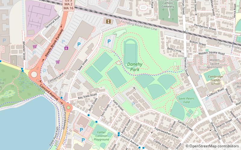
Thomas W. Danehy Park is a park in North Cambridge, Massachusetts. Its eastern entrance is at 99 Sherman Street. It is bounded on the north by the MBTA Fitchburg Line and to the west by Fresh Pond Mall. ()
Elevation: 16 ft a.s.l.Coordinates: 42°23'18"N, 71°8'14"W
Address
Cambridge (Neighborhood Nine)Belmont
ContactAdd
Social media
Add
Getting there by public transportation
Public transportation stops near this location
- Metro
- Bus
- Train
 Metro
Metro
- Calculate routeAlewife 15 min walk
- Calculate routeHarvard Square 36 min walk
- Calculate routeMassachusetts Ave @ Holyoke St 38 min walk
- Calculate routeAlewife 15 min walk
- Calculate routePorter 24 min walk
- Calculate routeDavis 25 min walk
- Calculate routeHarvard 35 min walk
- Calculate routePorter 25 min walk
Day trips


Frequently Asked Questions (FAQ)
Which popular attractions are close to Mayor Danehy Park?
Nearby attractions include Alewife Brook Parkway, Belmont (8 min walk), Rindge Towers, Arlington (10 min walk), Fresh Pond Hotel, Belmont (11 min walk), Fresh Pond Parkway, Belmont (12 min walk).
How to get to Mayor Danehy Park by public transport?
The nearest stations to Mayor Danehy Park:
Bus
Metro
Train
Bus
- Alewife (15 min walk)
- Harvard Square (36 min walk)
Metro
- Alewife • Lines: Red (15 min walk)
- Porter • Lines: Red (24 min walk)
Train
- Porter (25 min walk)