Oaksterdam, Oakland
Facts and practical information
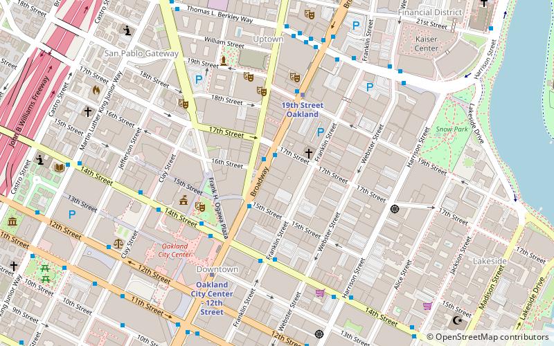
Oaksterdam is a cultural district on the north end of Downtown Oakland, California, where medical cannabis is available for purchase in cafés, clubs, and patient dispensaries. Oaksterdam is located between downtown proper, the Lakeside, and the financial district. It is roughly bordered by 14th Street on the southwest, Harrison Street on the southeast, 19th Street on the northeast, and Telegraph Avenue on the northwest. The name is a portmanteau of "Oakland" and "Amsterdam," due to the Dutch city's cannabis coffee shops and the drug policy of the Netherlands. Since 2005, cannabis has been available to patients with patient identification and physician recommendation at a busy dispensary in the neighborhood, one of Oakland's four officially licensed dispensaries under the current municipal ordinance. According to Proposition 215, a statewide voter initiative which amended the California Health and Safety Code, marijuana used for medical purposes is legal to possess and cultivate. Dispensaries require a doctor's note in order to obtain medical cannabis, which is legal under California Law but still illegal under the federal Controlled Substances Act. ()
1600 BroadwayCentral Oakland (Downtown Oakland)Oakland
- Metro
- Bus
- Train
- Ferry
 Metro
Metro
- Calculate routeBroadway & 17th Street 2 min walk
- Calculate routeBroadway & 14th Street 4 min walk
- Calculate routeBroadway & 19th Street 4 min walk
- Calculate route14th Street & Franklin Street 4 min walk
- Calculate route19th Street Oakland 5 min walk
- Calculate routeOakland City Center - 12th Street 6 min walk
- Calculate routeLake Merritt 17 min walk
- Calculate routeOakland-Jack London Square 22 min walk
- Calculate routeOakland Jack London Square Terminal 25 min walk


Frequently Asked Questions (FAQ)
Which popular attractions are close to Oaksterdam?
How to get to Oaksterdam by public transport?
Bus
- Broadway & 17th Street • Lines: 12, 18, 33, 51A, 6, 72, 72M, 800, 802, 805, 851 (2 min walk)
- Broadway & 14th Street • Lines: 18, 33, 6, 72, 72M, 72R, 800, 802, 805, 840 (4 min walk)
Metro
- 19th Street Oakland • Lines: Orange, Red, Yellow (5 min walk)
- Oakland City Center - 12th Street • Lines: Orange, Red, Yellow (6 min walk)
Train
- Oakland-Jack London Square (22 min walk)
Ferry
- Oakland Jack London Square Terminal • Lines: San Francisco Bay Ferry (25 min walk)