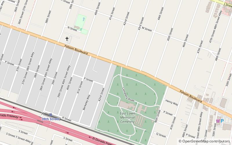
East Lawn Memorial Park, Sacramento
Map
Facts and practical information
East Lawn Memorial Park is a cemetery in the western United States, located in East Sacramento, California. It is owned by East Lawn Memorial Parks & Mortuaries, which also owns two other Sacramento area cemeteries. Founded in 1904, it is the resting place of several former Mayors of Sacramento as well as other public figures. ()
Coordinates: 38°33'48"N, 121°27'9"W
Getting there by public transportation
Public transportation stops near this location
- Bus
- Light rail
- Train
 Bus
Bus
- Calculate route39th Street 8 min walk
- Calculate route48th Street 10 min walk
- Calculate route29th Street 26 min walk
- Calculate route59th Street 28 min walk
- Calculate route39th Street 8 min walk
- Calculate route48th Street 10 min walk
- Calculate route29th Street 26 min walk
- Calculate route59th Street 27 min walk
- Calculate routeSacramento Midtown 27 min walk
Day trips


Frequently Asked Questions (FAQ)
Which popular attractions are close to East Lawn Memorial Park?
Nearby attractions include East Sacramento, Sacramento (13 min walk), McKinley Park, Sacramento (24 min walk).
How to get to East Lawn Memorial Park by public transport?
The nearest stations to East Lawn Memorial Park:
Light rail
Train
Bus
Light rail
- 39th Street • Lines: Gold (8 min walk)
- 48th Street • Lines: Gold (10 min walk)
Train
- 39th Street (8 min walk)
- 48th Street (10 min walk)
Bus
- Sacramento Midtown • Lines: 2062, 2064 (27 min walk)