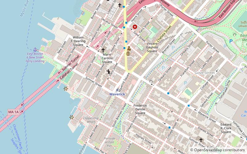
Maverick Square, Boston
Map
Facts and practical information
Maverick Square is a section of the neighborhood of East Boston in Boston, Massachusetts, United States. It is East Boston's oldest commercial center. At the heart of the square is Maverick Station, which is part of the Blue Line of the MBTA. ()
Coordinates: 42°22'11"N, 71°2'21"W
Address
East Boston (Central Maverick Square - Paris Street)Boston
ContactAdd
Social media
Add
Getting there by public transportation
Public transportation stops near this location
- Metro
- Bus
- Light rail
 Metro
Metro
- Calculate routeMaverick 2 min walk
- Calculate routeAirport 15 min walk
- Calculate routeAquarium 25 min walk
- Calculate routeWood Island 28 min walk
- Calculate routeHaymarket 29 min walk
- Calculate routeNorth Station 29 min walk
- Calculate routeGovernment Center 33 min walk
- Calculate routeFederal St @ Franklin St 34 min walk
- Calculate routeOtis St @ Summer St 38 min walk
Maps MBTA Subway
MBTA SubwayDay trips


Frequently Asked Questions (FAQ)
Which popular attractions are close to Maverick Square?
Nearby attractions include East Boston, Boston (10 min walk), Callahan Tunnel, Boston (10 min walk), Sumner Tunnel, Boston (10 min walk), Piers Park, Boston (10 min walk).
How to get to Maverick Square by public transport?
The nearest stations to Maverick Square:
Metro
Light rail
Bus
Metro
- Maverick • Lines: Blue (2 min walk)
- Airport • Lines: Blue (15 min walk)
Light rail
- Haymarket • Lines: C, E (29 min walk)
- North Station • Lines: C, E (29 min walk)
Bus
- Federal St @ Franklin St • Lines: 504 (34 min walk)
- Otis St @ Summer St • Lines: 504, 7 (38 min walk)