Petrie Bight Retaining Wall, Brisbane

Gallery (2)
Map
Map
Gallery
Facts and practical information
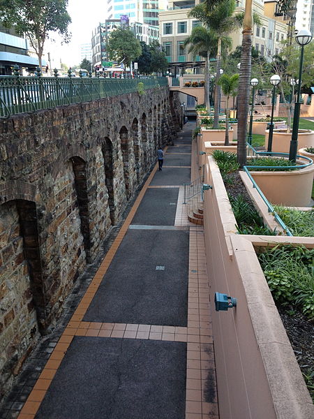
Petrie Bight Retaining Wall is a heritage-listed embankment at 443-501 Queen Street, Brisbane City, City of Brisbane, Queensland, Australia. It was built from 1881 to 1882 by Henry Patten. It was added to the Queensland Heritage Register on 21 October 1992. ()
Coordinates: 27°27'52"S, 153°1'52"E
Address
Brisbane CityBrisbane
ContactAdd
Social media
Add
Getting there by public transportation
Public transportation stops near this location
- Bus
- Train
- Ferry
 Bus
Bus
- Calculate routeQueen Street Stop 66 near Adelaide St 2 min walk
- Calculate routeAdelaide Street Stop 33 near Wharf St 2 min walk
- Calculate routeAnn Street Stop 5 at Orient Hotel 3 min walk
- Calculate routeQueen Street Stop 67 near Ann St 4 min walk
- Calculate routeHolman Street Ferry Terminal 5 min walk
- Calculate routeEagle Street Pier Ferry Terminal 8 min walk
- Calculate routeThornton Street Ferry Terminal 13 min walk
- Calculate routeDockside Ferry Terminal 19 min walk
- Calculate routeCentral 9 min walk
- Calculate routeFortitude Valley 16 min walk
- Calculate routeRoma Street 20 min walk
- Calculate routeExhibition 27 min walk
Day trips
Petrie Bight Retaining Wall – popular in the area (distance from the attraction)
Nearby attractions include: MacArthur Central, Customs House, ANZAC Square Arcade, Eagle Street Fig Trees.


Frequently Asked Questions (FAQ)
Which popular attractions are close to Petrie Bight Retaining Wall?
Nearby attractions include 444 Queen Street, Brisbane (1 min walk), 443 Queen Street, Brisbane (2 min walk), The Deanery, Brisbane (2 min walk), Customs House, Brisbane (2 min walk).
How to get to Petrie Bight Retaining Wall by public transport?
The nearest stations to Petrie Bight Retaining Wall:
Bus
Ferry
Train
Bus
- Queen Street Stop 66 near Adelaide St • Lines: 470 (2 min walk)
- Adelaide Street Stop 33 near Wharf St • Lines: 204 (2 min walk)
Ferry
- Holman Street Ferry Terminal • Lines: Chop-400, Xrvr-400 (5 min walk)
- Eagle Street Pier Ferry Terminal • Lines: Chop-400, Xrvr-400 (8 min walk)
Train
- Central (9 min walk)
- Fortitude Valley (16 min walk)