Bremer River Rail Bridge, Ipswich

Facts and practical information
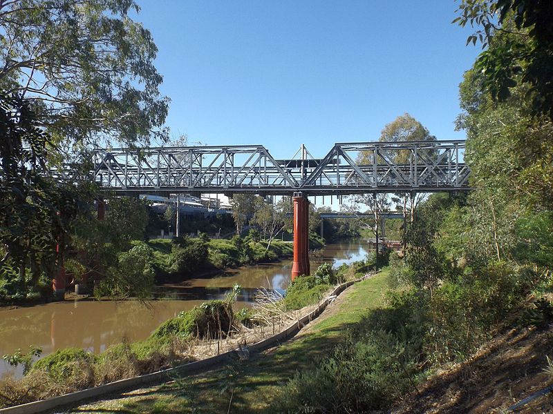
The Bremer River Rail Bridge is an essential piece of infrastructure in the city of Ipswich, Australia, serving as a vital link across the Bremer River for the region's railway network. This bridge is a testament to the city's industrial heritage and its ongoing commitment to maintaining and improving transportation routes for both economic and public service.
Constructed to facilitate the burgeoning rail transport demands of Ipswich, a city with a rich history in rail and industry, the Bremer River Rail Bridge has been a part of the landscape for many years. While not as internationally recognized as some iconic bridges, it plays a crucial role in the daily operation of the region's rail system, supporting freight and passenger services that connect Ipswich with the greater Queensland area and beyond.
The bridge's design is functional, reflecting its purpose as a utilitarian structure. It is built to withstand the challenges posed by the river below, including varying water levels and weather conditions. The durability of the bridge is a testament to the engineering skills employed in its construction and the ongoing maintenance efforts to ensure its longevity and safety.
Access to the bridge is restricted to rail traffic, as it is not designed for pedestrian or vehicular use. However, its presence is a familiar sight to local residents and a point of interest for rail enthusiasts and those interested in the industrial history of the area.
IpswichIpswich
- Bus
- Train
 Bus
Bus
- Calculate routeIpswich 6 min walk
- Calculate routeNorth Ipswich 21 min walk
- Calculate routeThomas Street 23 min walk
- Calculate routeEast Ipswich 26 min walk
- Calculate routeBell Street Interchange, Stop C 6 min walk
- Calculate routeBell Street Interchange, Stop A 6 min walk
- Calculate routeRiverlink stop A 6 min walk
- Calculate routeBell Street Interchange, Stop B 7 min walk
Bremer River Rail Bridge – popular in the area (distance from the attraction)
Nearby attractions include: Riverlink Shopping Centre, St. Mary's Church, Soldiers' Memorial Hall, Walter Burley Griffin Incinerator.


Frequently Asked Questions (FAQ)
Which popular attractions are close to Bremer River Rail Bridge?
How to get to Bremer River Rail Bridge by public transport?
Train
- Ipswich (6 min walk)
- North Ipswich (21 min walk)
Bus
- Bell Street Interchange, Stop C • Lines: 500, 502, 503, 506, 509, 512, 529 (6 min walk)
- Bell Street Interchange, Stop A • Lines: 500, 502, 503, 506, 509, 512, 514, 515 (6 min walk)