Mount Cooper, Melbourne
Map
Facts and practical information
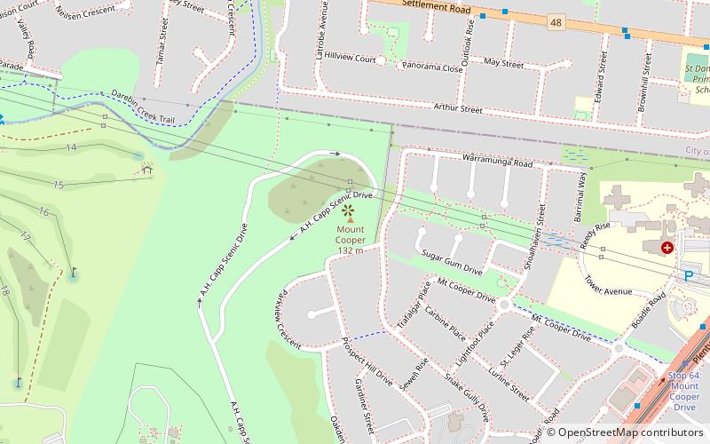
Mount Cooper is located within Bundoora Park, a large public park, in the Melbourne suburb of Bundoora, and peaks at 137 meters above sea level. Mount Cooper is accessible by car via Mount Cooper Scenic Drive. ()
Coordinates: 37°42'4"S, 145°2'53"E
Address
Banyule (Bundoora)Melbourne
ContactAdd
Social media
Add
Getting there by public transportation
Public transportation stops near this location
- Bus
- Tram
 Bus
Bus
- Calculate routeNorris Bank Reserve 9 min walk
- Calculate routeOutlook Rise 9 min walk
- Calculate routeLatrobe Avenue 9 min walk
- Calculate routeEmms Street 9 min walk
- Calculate routeStop 64: Mount Cooper Drive 13 min walk
- Calculate routeStop 63: Greenwood Drive 14 min walk
- Calculate routeStop 65: Grimshaw Street 15 min walk
- Calculate routeStop 66: Settlement Road 16 min walk
Maps Melbourne TramsMaps
 Victoria Trains
Melbourne TramsMapsVictoria TrainsDay trips


Frequently Asked Questions (FAQ)
How to get to Mount Cooper by public transport?
The nearest stations to Mount Cooper:
Bus
Tram
Bus
- Norris Bank Reserve • Lines: 902 (9 min walk)
- Outlook Rise • Lines: 902 (9 min walk)
Tram
- Stop 64: Mount Cooper Drive • Lines: 86, 86d (13 min walk)
- Stop 63: Greenwood Drive • Lines: 86, 86d (14 min walk)