Degraves Street, Melbourne

Gallery (4)
Map

Map
Gallery
Facts and practical information
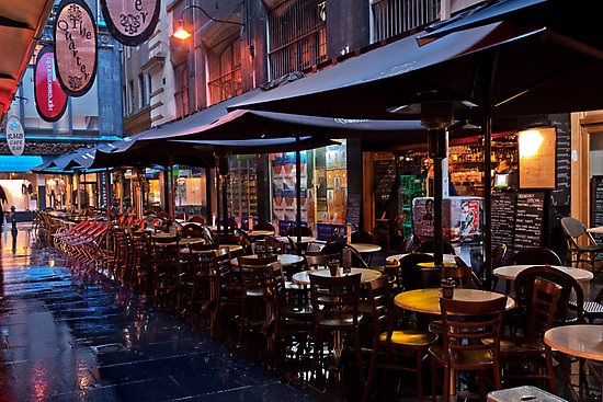
Degraves Street is a pedestrian precinct and thoroughfare in Melbourne, Victoria, Australia. It is a short, narrow laneway in the Central Business District that runs north–south from Flinders Street to Flinders Lane and is situated in-between Swanston Street and Elizabeth Street. Degraves, as the street is colloquially known, is famous for its alfresco dining options and because it epitomises Melbourne's coffee culture and street art scene. For these reasons it has also become a popular tourist destination. ()
Coordinates: 37°49'3"S, 144°57'58"E
Address
City of Melbourne (Melbourne CBD)Melbourne
ContactAdd
Social media
Add
Getting there by public transportation
Public transportation stops near this location
- Bus
- Tram
- Train
- Ferry
 Bus
Bus
- Calculate routeStop 5: Flinders Street Station, Swanston Street 2 min walk
- Calculate routeStop 1: Flinders Street Station 2 min walk
- Calculate routeStop 4: Flinders Street Station, Elizabeth Street 3 min walk
- Calculate routeStop 11: City Square, Collins Street 3 min walk
- Calculate routeFlinders Street 2 min walk
- Calculate routeMelbourne Central 15 min walk
- Calculate routeParliament 16 min walk
- Calculate routeFlagstaff 18 min walk
- Calculate routeFlinders Lane/Queen Street 6 min walk
- Calculate routeBanana Alley Vaults/Flinders Street 7 min walk
- Calculate routeMarket Street/Flinders Street 7 min walk
- Calculate routeCollins Street/Queen Street 7 min walk
- Calculate routePort Phillip Ferries 30 min walk
Maps Melbourne TramsMaps
 Victoria Trains
Melbourne TramsMapsVictoria TrainsDay trips


Frequently Asked Questions (FAQ)
Which popular attractions are close to Degraves Street?
Nearby attractions include Port Phillip Arcade, Melbourne (2 min walk), Flinders Lane, Melbourne (2 min walk), Centre Place, Melbourne (2 min walk), Nicholas Building, Melbourne (2 min walk).
How to get to Degraves Street by public transport?
The nearest stations to Degraves Street:
Tram
Train
Bus
Ferry
Tram
- Stop 5: Flinders Street Station, Swanston Street • Lines: 35, 70, 70d, 75 (2 min walk)
- Stop 1: Flinders Street Station • Lines: 19, 57, 59, 59d (2 min walk)
Train
- Flinders Street (2 min walk)
- Melbourne Central (15 min walk)
Bus
- Flinders Lane/Queen Street • Lines: 216, 220, 234, 236, 605 (6 min walk)
- Banana Alley Vaults/Flinders Street • Lines: 234, 236, 605 (7 min walk)
Ferry
- Port Phillip Ferries (30 min walk)