De Burghs Bridge, Sydney
Map
Facts and practical information
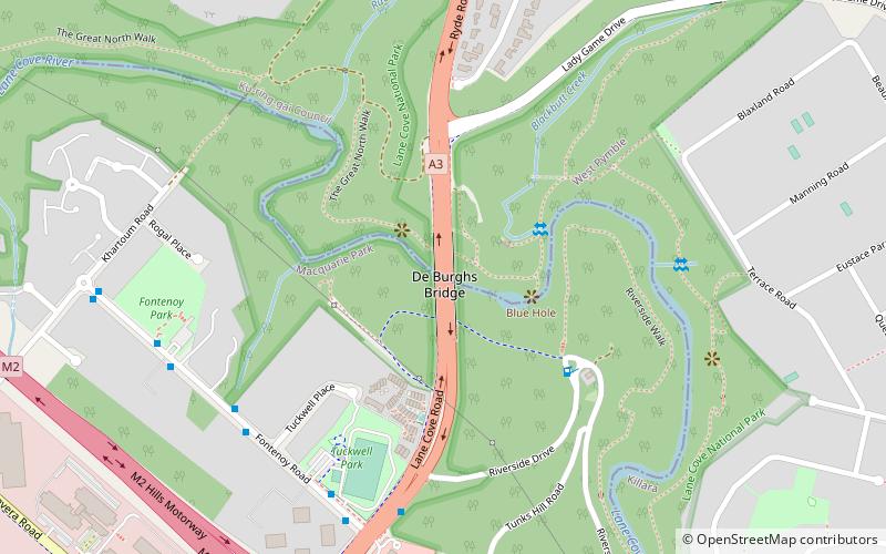
De Burghs Bridge is a road bridge that carries the Lane Cove Road, part of the A3, across the Lane Cove River in Macquarie Park, Sydney, Australia. The bridge stretches from Macquarie Park in the south to West Pymble in the north. ()
Coordinates: 33°46'32"S, 151°8'7"E
Address
Ryde (Macquarie Park)Sydney
ContactAdd
Social media
Add
Getting there by public transportation
Public transportation stops near this location
- Metro
- Bus
 Metro
Metro
- Calculate routeTuckwell Pl 7 min walk
- Calculate routeFontenoy Rd 8 min walk
- Calculate routeMacquarie Park 20 min walk
Maps Sydney TrainsMaps
 Sydney Light RailMaps
 Sydney Ferries
Sydney TrainsMapsSydney Light RailMapsSydney FerriesDay trips


Frequently Asked Questions (FAQ)
Which popular attractions are close to De Burghs Bridge?
Nearby attractions include Sydney/Macquarie Park, Sydney (18 min walk), Fiddens Wharf, Sydney (20 min walk).
How to get to De Burghs Bridge by public transport?
The nearest stations to De Burghs Bridge:
Bus
Metro
Bus
- Tuckwell Pl • Lines: 259 (7 min walk)
- Fontenoy Rd • Lines: 545 (8 min walk)
Metro
- Macquarie Park • Lines: Sydney Metro Northwest (20 min walk)