Pflunspitzen
#496 among destinations in Austria
![Pflunspitzen location map](https://tzmedia.b-cdn.net/media/images/static-maps/at/47_0794_10_1328.jpg)
Facts and practical information
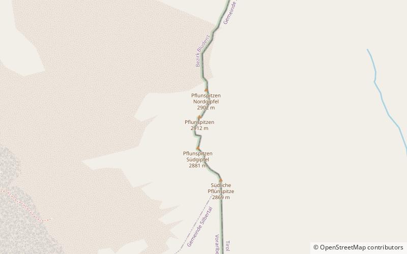
The Pflunspitzen are the highest points in the western Verwall Group in the Austrian Alps, reaching a maximum height of 2,912 m. They lie west of the neighbouring Kaltenberg; the nearest village is Klösterle by Arlberg north of the peaks. ()
VorarlbergAustria
Pflunspitzen plan & book
Unleash the traveler in you — discover the cheapest flight deals, find the perfect hotel or hostel nearby, and search for the best car rental prices. Travel at your own pace to discover new places and enjoy your journey.
Pflunspitzen – popular in the area (distance from the attraction)
Nearby attractions include: Ski Arlberg, Valluga, Galzig, Patteriol.
6.6 miNEWinter sport, Ski areaSki Arlberg, St. Anton
168 min walk • The Ski Arlberg ski area is situated in the Arlberg massif in the Austrian states of Vorarlberg and Tyrol. The area consists of two parts, namely: Arlberg East and Arlberg West. Arlberg East consists of the villages of St. Anton am Arlberg, St. Christoph am Arlberg and Stuben am Arlberg.
6.6 miNENature, Natural attraction, MountainValluga
168 min walk • Valluga is a prominent peak that commands the alpine skyline of St. Anton am Arlberg in Austria. At an elevation of 2,811 meters, it stands as a beacon for winter sports enthusiasts and mountaineers alike. Known for its panoramic views that stretch across the alpine...
5.8 miNENature, Natural attraction, MountainGalzig
147 min walk • Galzig is a mountain in the Lechtal Alps of Tyrol, Austria. The elevation at its peak is 2,184 metres. Located near St. Anton am Arlberg, it is a popular hiking and skiing destination, depending on the season.
3.5 miSENature, Natural attraction, MountainPatteriol
91 min walk • The Patteriol is a mountain in the Verwall Alps in the Austrian state of Tyrol. It has an elevation of 3,056 m. In old literature the elevation is stated higher: 3,059 m or 10,037 ft.
4.4 miENature, Natural attraction, MountainScheibler Mountain
113 min walk • Scheibler is a 2,978 m high mountain in the Verwall Alps in the Austrian state Tyrol. There are directs ascents from two alpine club huts: From Darmstädter Hütte in two hours. From Konstanzer Hütte in three hours. Both ascents meet at Kuchenjöchli, the 2,730-metre-high col between Scheibler and Kuchenspitze.
5 miSENature, Natural attraction, MountainKuchenspitze
129 min walk • The Kuchenspitze is a mountain, 3,148 m, in the Verwall between the valley of Stanzer Tal and Paznaun in the west of North Tyrol.
5.4 miSENature, Natural attraction, MountainKüchlspitze
138 min walk • The Küchlspitze is a three-thousander in the Verwall between the valley of Stanzer Tal and Paznaun in the western North Tyrol in Austria.
4.9 miNNature, Natural attraction, Mountain passFlexen Pass
126 min walk • Flexen Pass is a high mountain pass in the Austrian Alps in the Bundesland of Vorarlberg. It is at an elevation of 1,773 metres. It connects the upper Lech valley between Warth, Lech, and Zürs with the Klostertal near Stuben. The pass road was built in 1940 and leads to the road over the Arlberg pass.
4.1 miNW 5.6 miEAlpine hut, HikingDarmstädter Hütte
144 min walk • The Darmstädter Hütte is an alpine club hut of the Darmstadt-Starkenburg Section of the German Alpine Club in the municipality of St. Anton am Arlberg in the Verwallgruppe in Tyrol.