Main Square, Toronto

Gallery (1)
Map
Map
Facts and practical information
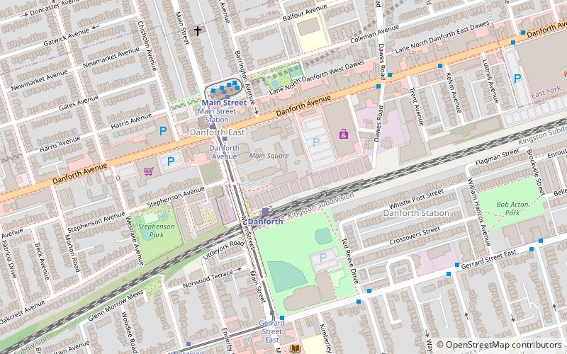
Main Square is a complex of four apartment buildings in Toronto, Canada. The three-hectare site houses about 2000 people. It is located in the eastern part of the city at the intersection of Main Street and Danforth Avenue. The complex is located just north of the railway lines and the Danforth GO Station and just south of the Main Street subway station. It consists of four towers, the tallest being 32 stories. At ground level, there is also a shopping plaza along Danforth and a city-run community centre. ()
Coordinates: 43°41'14"N, 79°17'59"W
Address
East End (East Danforth)Toronto
ContactAdd
Social media
Add
Getting there by public transportation
Public transportation stops near this location
- Metro
- Bus
- Tram
- Train
 Metro
Metro
- Calculate routeDanforth 2 min walk
- Calculate routeDanforth Avenue 4 min walk
- Calculate routeGerrard Street East 6 min walk
- Calculate routeMain Street 6 min walk
- Calculate routeMain Street 4 min walk
- Calculate routeWoodbine 17 min walk
- Calculate routeVictoria Park 20 min walk
- Calculate routeCoxwell 31 min walk
- Calculate routeMain Street Station 5 min walk
- Calculate routeGerrard Street East 6 min walk
- Calculate routeMain Street 6 min walk
- Calculate routeOsborne Avenue 6 min walk
Maps SubwayMaps
 Streetcar systemMaps
 PATH
PATH
SubwayMapsStreetcar systemMapsPATHDay trips


Frequently Asked Questions (FAQ)
Which popular attractions are close to Main Square?
Nearby attractions include East Danforth, Toronto (4 min walk), Crescent Town, Toronto (17 min walk), Upper Beaches, Toronto (22 min walk), Old East York, Toronto (24 min walk).
How to get to Main Square by public transport?
The nearest stations to Main Square:
Train
Tram
Metro
Bus
Train
- Danforth (2 min walk)
Tram
- Danforth Avenue • Lines: 306, 506 (4 min walk)
- Gerrard Street East • Lines: 306, 506 (6 min walk)
Metro
- Main Street • Lines: 2 (4 min walk)
- Woodbine • Lines: 2 (17 min walk)
Bus
- Main Street Station • Lines: 62 (5 min walk)
- Gerrard Street East • Lines: 135, 64 (6 min walk)