Ontario Food Terminal, Toronto

Gallery (1)
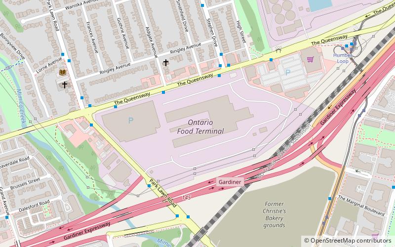
Map
Map
Facts and practical information
The Ontario Food Terminal is the main produce distribution centre for Toronto, Ontario, Canada. It is located at 165 The Queensway at Park Lawn Road, north of the Gardiner Expressway, and west of the Humber River. The U-shaped building occupies 1,740,000 square feet of a 40 acres site and includes 80,000 square feet of cold storage and is open 24 hours a day, 365 days a year for deliveries. Annually some one million vehicles arrive at the centre delivering produce from across North America or leave to distribute it to stores and restaurants across the city. It is the largest such facility in Canada, and the third largest in North America after those in Chicago and Los Angeles. ()
Coordinates: 43°37'43"N, 79°29'7"W
Getting there by public transportation
Public transportation stops near this location
- Bus
- Tram
- Train
 Bus
Bus
- Calculate routeStop 10 min walk
- Calculate routeSouth Kingsway 21 min walk
- Calculate routeWindermere Avenue 25 min walk
- Calculate routeEllis Avenue 29 min walk
- Calculate routeMimico 26 min walk
Maps SubwayMaps
 Streetcar systemMaps
 PATH
PATH
SubwayMapsStreetcar systemMapsPATHDay trips


Frequently Asked Questions (FAQ)
Which popular attractions are close to Ontario Food Terminal?
Nearby attractions include The Queensway–Humber Bay, Toronto (4 min walk), The Palace Pier, Toronto (18 min walk), Humber Bay Park, Toronto (18 min walk), Humber Bay Arch Bridge, Toronto (19 min walk).
How to get to Ontario Food Terminal by public transport?
The nearest stations to Ontario Food Terminal:
Tram
Bus
Train
Tram
- Stop • Lines: 501, 501;301 (10 min walk)
Bus
- South Kingsway • Lines: 80A (21 min walk)
- Windermere Avenue • Lines: 80A (25 min walk)
Train
- Mimico (26 min walk)