Britannia Heights, Ottawa
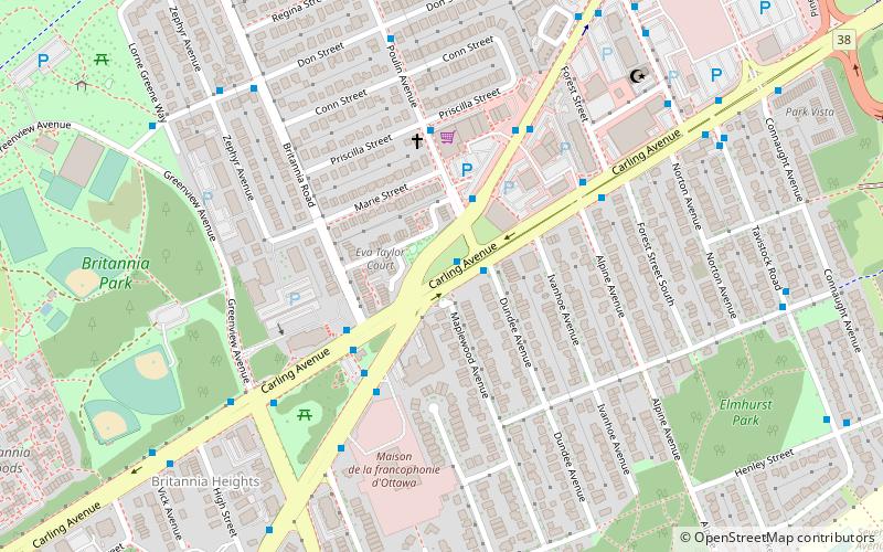
Map
Facts and practical information
Britannia Heights is a neighbourhood in Bay Ward in west end of Ottawa, Ontario, Canada. The neighbourhood is a sub-neighbourhood of Britannia area of the city, but is within the Queensway Terrace North Community Association boundaries. The neighbourhood is away from the Ottawa River on a steep hill. It is bounded to the North by Carling Avenue, east by OC Transpo Transitway, south by Henley Street, and west by Bayshore Drive. The population of the neighbourhood is approximately 1750. ()
Area: 0.44 mi²Coordinates: 45°21'40"N, 75°47'30"W
Address
Lincoln HeightsOttawa
ContactAdd
Social media
Add
Getting there by public transportation
Public transportation stops near this location
- Bus
 Bus
Bus
- Calculate routeCarling / Richmond 1 min walk
- Calculate routeRichmond / Poulin 2 min walk
- Calculate routeCarling / Britannia 3 min walk
Day trips


Frequently Asked Questions (FAQ)
Which popular attractions are close to Britannia Heights?
Nearby attractions include Queensway Terrace North, Ottawa (9 min walk), St. Stephen's Anglican Church, Ottawa (12 min walk), Britannia United Church, Ottawa (13 min walk), Belltown, Ottawa (14 min walk).
How to get to Britannia Heights by public transport?
The nearest stations to Britannia Heights:
Bus
Bus
- Carling / Richmond • Lines: 57, 85 (1 min walk)
- Richmond / Poulin • Lines: 11, 51 (2 min walk)