Country Hills, Calgary
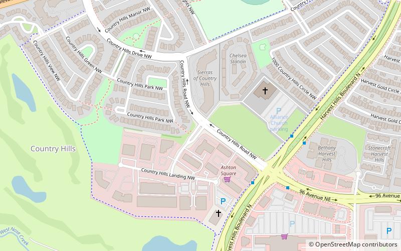
Map
Facts and practical information
Country Hills is a residential neighbourhood in the northwest quadrant of Calgary, Alberta. It is bounded to the north by the Country Hills Boulevard, to the south by Beddington Trail, and to the east by Harvest Hills Boulevard. To the southwest, it is bordered by the Country Hills golf course which began construction in 1989 and opened in 1992. The clubhouse along with the fully developed course opened in 1999. the area is also bordered by the West Nose Creek. The new community of Country Hills Village is located in the northeast of the neighbourhood. Country Hills is a generally calm and quiet area. ()
Coordinates: 51°8'37"N, 114°4'20"W
Getting there by public transportation
Public transportation stops near this location
- Bus
 Bus
Bus
- Calculate routeSB Harvest Hills BV @ 96 AV NE 4 min walk
- Calculate routeNB Harvest Hills BV @ 96 AV NE 5 min walk
- Calculate routeEB 96 AV NE @ Harvest Hills BV 6 min walk
- Calculate routeWB 96 AV NE @ Harvest Rose PA 11 min walk
Day trips


Frequently Asked Questions (FAQ)
How to get to Country Hills by public transport?
The nearest stations to Country Hills:
Bus
Bus
- SB Harvest Hills BV @ 96 AV NE • Lines: 300, 301 (4 min walk)
- NB Harvest Hills BV @ 96 AV NE • Lines: 301 (5 min walk)