Parkway Park, Ottawa
Map
Facts and practical information
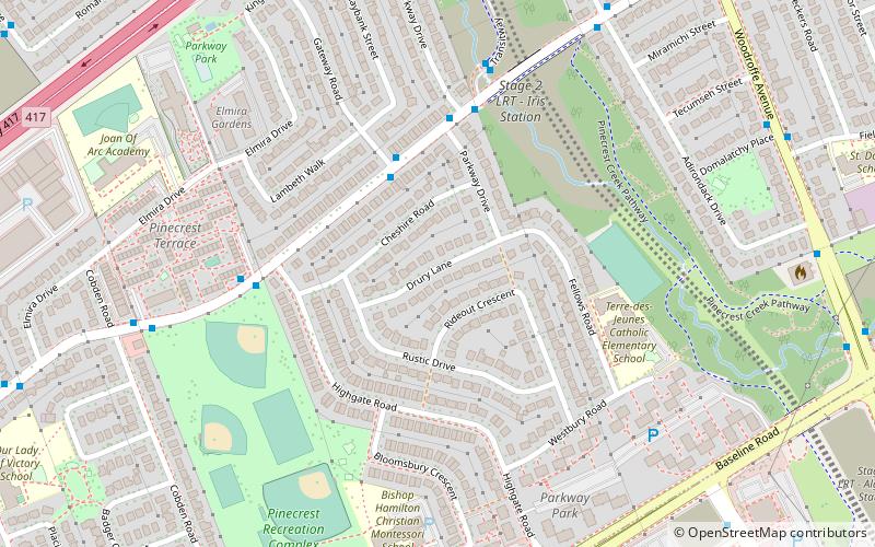
Parkway Park is a neighbourhood in College Ward in Ottawa, Ontario, Canada. It is bounded to the north by the Queensway, to the west Cobden Road, to the south by Baseline Road and to the east by Pinecrest Creek and the OC Transpo Transitway. ()
Coordinates: 45°21'10"N, 75°46'17"W
Address
Parkway ParkOttawa
ContactAdd
Social media
Add
Getting there by public transportation
Public transportation stops near this location
- Bus
 Bus
Bus
- Calculate routeIris / Gateway 3 min walk
- Calculate routeIris / Parkway 5 min walk
- Calculate routeIris / Highgate 5 min walk
- Calculate routeIris 1A 6 min walk
Day trips


Frequently Asked Questions (FAQ)
Which popular attractions are close to Parkway Park?
Nearby attractions include Kenson Park, Ottawa (9 min walk), Ridgeview, Ottawa (13 min walk), Bel-Air Park, Ottawa (14 min walk), Legacy Skatepark, Ottawa (19 min walk).
How to get to Parkway Park by public transport?
The nearest stations to Parkway Park:
Bus
Bus
- Iris / Gateway • Lines: 58 (3 min walk)
- Iris / Parkway • Lines: 58 (5 min walk)