Mont Turia
#912 among destinations in France
Facts and practical information
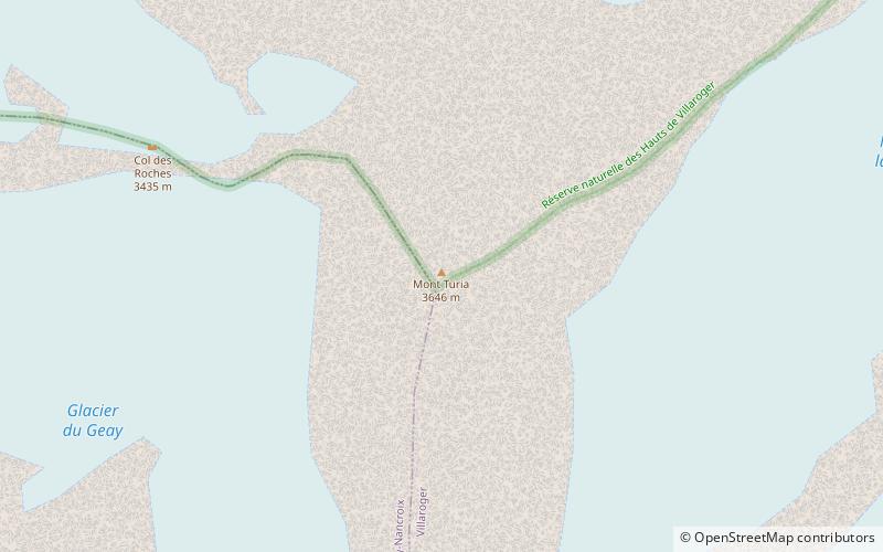
Mont Turia is a shoulder on the north ridge of Mont Pourri in Savoie, France. It lies in the Massif de la Vanoise range. It has an elevation of 3,646 metres above sea level. ()
Auvergne-Rhône-AlpesFrance
Mont Turia plan & book
Unleash the traveler in you — discover the cheapest flight deals, find the perfect hotel or hostel nearby, and search for the best car rental prices. Travel at your own pace to discover new places and enjoy your journey.
Mont Turia – popular in the area (distance from the attraction)
Nearby attractions include: Tignes-les-Brévières, Paradiski, Lac de Tignes, Bellecôte.
- 3.7 miSEWinter sport, Ski area
Tignes-les-Brévières
94 min walk • Nestled in the heart of the French Alps, Tignes-les-Brévières is a captivating ski area that promises an unforgettable alpine experience. This picturesque village, part of the larger Tignes ski resort, offers a blend of traditional charm and modern skiing facilities.
- 5 miWWinter sport, Ski area
Paradiski, Peisey-Nancroix
128 min walk • Paradiski is a ski-area in the Tarentaise Valley of France that offers uninterrupted skiing in between the areas of Les Arcs, Peisey-Vallandry and La Plagne. The area is linked, since December 2003, by the Vanoise Express lift.
- 5.1 miSENature, Natural attraction, Lake
Lac de Tignes, Tignes
131 min walk • Lac de Tignes is a lake at Tignes in the Savoie department of France.
- 4.7 miSWNature, Natural attraction, Mountain
Bellecôte
120 min walk • The Bellecôte is a mountain in the Vanoise Massif in the Graian Alps, lying in the northern part of the Vanoise National Park and dominating the Peisey-Nancroix valley in Savoie. The north face is immense and austere, whereas the south face is more accessible.
- ~1720 ftSNature, Natural attraction, Mountain
Mont Pourri
9 min walk • Mont Pourri is a mountain in the Vanoise Massif in the Graian Alps. It is located in the Vanoise National Park, nearby Les Arcs ski resort.
- 1.7 miNWScenic mountain for hiking and skiing
Aiguille Rouge, Les Arcs
43 min walk • Aiguille Rouge is a mountain of Savoie, France. It lies in the Vanoise Massif and has an elevation of 3,227 metres above sea level. It is the highest point within the ski area of Les Arcs and is a fairly easy hike from the village below. It can also be accessed by a cable-car which almost reaches the summit area.
- 1.6 miSNature, Natural attraction, Mountain
Dôme de la Sache
41 min walk • Dôme de la Sache is a mountain of Savoie, France. It lies in the Massif de la Vanoise range. It has an elevation of 3,601 metres above sea level.
- 4.1 miNArea
Villaroger, Sainte-Foy-Tarentaise
104 min walk • Villaroger is a commune in the Savoie department in the Auvergne-Rhône-Alpes region in south-eastern France. It is situated in the upper Tarentaise Valley, between Bourg-Saint-Maurice and Tignes.
- 6.8 miNE
- 1.5 miSNature, Natural attraction, Mountain
Dôme des Platières
38 min walk • Dôme des Platières is a mountain of Savoie, France. It lies in the Massif de la Vanoise range. It has an elevation of 3,473 metres above sea level.
- 3.8 miWChurch
Notre-Dame des Vernettes, Les Arcs
98 min walk • The sanctuary of Notre-Dame des Vernettes is located on the territory of the commune of Peisey-Nancroix in Savoie. It was built in the 18th century.