Piz Calderas
#818 among destinations in Switzerland
![Piz Calderas location map](https://tzmedia.b-cdn.net/media/images/static-maps/ch/46_5364_9_69598.jpg)
Facts and practical information
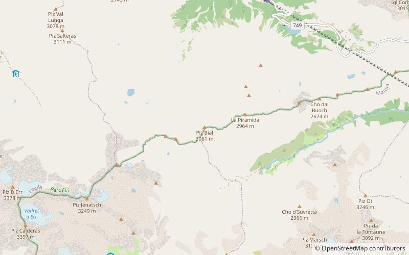
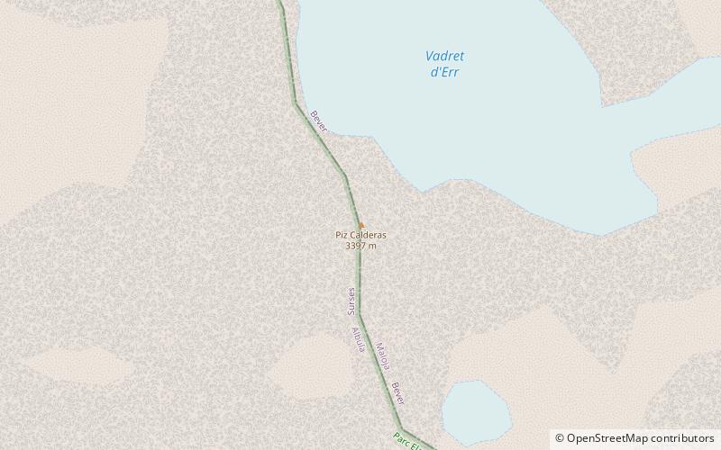
Piz Calderas is a mountain of the Albula Alps, overlooking Mulegns in the canton of Graubünden. It is the highest summit of the group located between the Julier and Albula Pass. On its east side lies the Val Bever. ()
GraubündenSwitzerland
Piz Calderas plan & book
Unleash the traveler in you — discover the cheapest flight deals, find the perfect hotel or hostel nearby, and search for the best car rental prices. Travel at your own pace to discover new places and enjoy your journey.
Piz Calderas – popular in the area (distance from the attraction)
Nearby attractions include: Lai da Palpuogna, Piz Nair, Lai Blos, Marmels Castle.
5.3 miNENature, Natural attraction, LakeLai da Palpuogna
135 min walk • Nestled in the heart of the Swiss Alps, Lai da Palpuogna is a hidden gem that provides a serene escape from the hustle and bustle of modern life. This idyllic lake, located in the Canton of Grisons in Switzerland, is a tranquil haven for nature lovers and those seeking...
4.8 miSENatural attraction, Mountain, LookoutPiz Nair, St. Moritz
123 min walk • Piz Nair is a towering presence in the luxury alpine resort town of St. Moritz, Switzerland. Rising to an impressive 3,056 meters above sea level, this mountain grants visitors a breathtaking panorama of the Engadin valley and the surrounding peaks of the Swiss Alps.
2.6 miWNature, Natural attraction, LakeLai Blos
67 min walk • Lai Blos or Lais Blos are two small lakes on Alp Flix, at an elevation of 1960 m, in the Grisons, Switzerland. They are located near to Lai Neir. The alp is listed in the Inventory of Mire Landscapes of Particular Beauty and National Importance.
3.8 miSWForts and castlesMarmels Castle
98 min walk • Marmels Castle German: Burg Marmels is a ruined castle in the municipality of Marmorera in the district of Albula in the canton of Graubünden in Switzerland.
3.6 miSWForts and castlesSpliatsch Castle
91 min walk • Spliatsch Castle is a ruined castle in the municipality of Surses in the Albula Region in the canton of Graubünden in Switzerland.
4.4 miSEProminent mountain with dramatic viewsPiz Julier
112 min walk • Piz Julier is a mountain of the Albula Alps, overlooking the Julier Pass, in the Swiss canton of Graubünden. With a height of 3,380 metres above sea level, Piz Julier is the second highest peak of the group between the Julier Pass and the Albula Pass.
4.6 miNNature, Natural attraction, MountainPiz Ela
119 min walk • Piz Ela is a mountain in the Albula Alps, overlooking Bergün, in the Swiss canton of Graubünden. It is located in the center of the nature park Parc Ela. There is a lake called Lai Grond to the south of Piz Ela.
4.7 miSMountain passJulier Pass, Sils im Engadin/Segl
120 min walk • The Julier Pass is a mountain pass in Switzerland, in the Albula Alps. It connects the Engadin valley with central Graubünden, the nearest inhabited localities on its approaches being Silvaplana and Bivio.
1 miSNature, Natural attraction, MountainTschima da Flix
27 min walk • Tschima da Flix is a mountain of the Albula Alps, located between Piz Calderas and Piz d'Agnel, in the canton of Graubünden. On the northern side of the mountain lies a glacier named Vadret da Calderas.
3.3 miNEMountainPiz Bial, Samedan
83 min walk • Piz Bial is a mountain of the Albula Alps, located in Graubünden, Switzerland. It is situated between the Val Mulix and the Val Bever. The closest locality is Preda, on the Albula Railway.
3.7 miSMountainPiz Neir, Sils im Engadin/Segl
94 min walk • Piz Neir is a mountain of the Albula Alps, overlooking Bivio in the canton of Graubünden. It lies on the group south of Piz d'Agnel.