Matro
#1715 among destinations in Switzerland
![Matro location map](https://tzmedia.b-cdn.net/media/images/static-maps/ch/46_4101_8_92467.jpg)
Facts and practical information
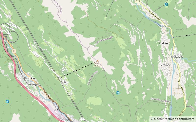
The Matro is a mountain of the Swiss Lepontine Alps, overlooking Giornico in the canton of Ticino. It lies at the southern end of the chain separating the main Leventina valley from the Blenio valley. An antenna is located on the summit. ()
TicinoSwitzerland
Matro plan & book
Unleash the traveler in you — discover the cheapest flight deals, find the perfect hotel or hostel nearby, and search for the best car rental prices. Travel at your own pace to discover new places and enjoy your journey.
Matro – popular in the area (distance from the attraction)
Nearby attractions include: Pizzo Magn, Cima di Gana Bianca, Bacino di Val Malvaglia, Madom Gröss.
5.2 miSENature, Natural attraction, MountainPizzo Magn
134 min walk • Pizzo Magn or Monte Crenone is a mountain of the Swiss Lepontine Alps, overlooking Biasca in the canton of Ticino. It is located west of the Mottone di Cava.
5.3 miNENature, Natural attraction, MountainCima di Gana Bianca
135 min walk • The Cima di Gana Bianca is a mountain of the Swiss Lepontine Alps, overlooking Acquarossa in the canton of Ticino. It lies west of the Rheinwaldhorn, between the main Blenio valley and the Val Malvaglia.
4.7 miENature, Natural attraction, LakeBacino di Val Malvaglia
121 min walk • Bacino di Val Malvaglia is a lake above Malvaglia in the canton of Ticino, Switzerland. The reservoir's surface area is 0.19 km². Its arch dam was built in 1959 and is operated by Officine Idroelettriche di Blenio SA.
5.4 miSWNature, Natural attraction, MountainMadom Gröss
137 min walk • The Madom Gröss is a mountain in the Lepontine Alps of Switzerland. It is located between the Valle Verzasca and Valle Leventina, near Sonogno, Ticino.
4.7 miSWNature, Natural attraction, Natural featureLepontine Alps
121 min walk • The Lepontine Alps are a mountain range in the north-western part of the Alps. They are located in Switzerland and Italy. The Simplon rail tunnel the Gotthard rail and Gotthard road tunnels and the San Bernardino road tunnel are important transport arteries.
2.5 miWSacred and religious sites, ChurchChiesa di San Nicolao, Giornico
64 min walk • The church of San Nicola was built in the 12th century. It stands in the middle of a vineyard on the right bank of the Ticino River in Giornico in Leventina in the Swiss canton of Ticino.
2.7 miNWNature, Natural attraction, MountainPizzo Erra
69 min walk • Pizzo Erra is a mountain of the Lepontine Alps, located in the Swiss canton of Ticino. It is located south of the pass of Basso di Nara, on the subrange that separates the main valley of Leventina from the valley of Blenio.
2.5 miNENature, Natural attraction, ValleyBlenio Valley
63 min walk • The Blenio Valley is a valley of the Lepontine Alps in the Swiss canton of Ticino. The valley contains the river Brenno. The upper valley, between Lai da Sontga Maria and Olivone, is named Valle Santa Maria.
2.6 miWSacred and religious sites, ChurchChiesa di Santa Maria del Castello, Giornico
67 min walk • The church of Santa Maria di Castello stands on a prominent rocky hill to the west above the municipality of Giornico in Leventina in the Swiss canton of Ticino.
4.2 miSEChurchChurch of Saints Peter and Paul, Biasca
107 min walk • The church of Sts. Peter and Paul stands east above the village of Biasca on a rocky ridge in the Swiss canton of Ticino. It was built between the end of the 11th and the beginning of the 12th centuries and, with its gallery of murals from various...
4.5 miENature, Natural attraction, MountainPizzo Muncréch
116 min walk • Pizzo Muncréch is a mountain in the Swiss Lepontine Alps, overlooking Malvaglia in the canton of Ticino. It is located west of Piz di Strega, between the valleys of Combra and Pontirone.