Croix de Fer
#1046 among destinations in Switzerland

Facts and practical information
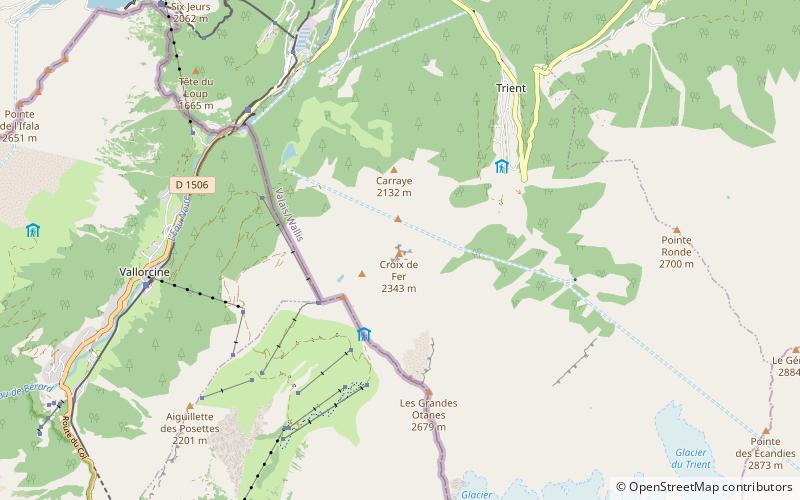
The Croix de fer is a mountain of the Mont Blanc Massif, overlooking Trient in the canton of Valais. It is located north of the Tête de Balme and L'Arolette and it is the culminating point of the group between the Col des Montets and the Col de Balme. ()
ValaisSwitzerland
Croix de Fer – popular in the area (distance from the attraction)
Nearby attractions include: Trient Hut, Château de la Bâtiaz, Fondation Pierre Gianadda, Saleina Hut.
 Alpine hut, Hiking
Trient Hut
105 min walk • Nestled in the embrace of the Swiss Alps, the Trient Hut is a beacon for mountaineers and hikers traversing the snowy landscapes of Switzerland. This alpine hut, perched at an altitude of 3170 meters, offers a respite from the rugged terrains of the Mont Blanc massif.
 Forts and castles
Château de la Bâtiaz, Martigny
166 min walk • La Bâtiaz Castle is a castle in the municipality of Martigny, in the Canton of Valais, Switzerland. It is a Swiss heritage site of national significance. The garderobes at La Bâtiaz played a part in determining that the architect for the UNESCO listed castles in Wales came from Savoy before working in Wales. Historian and custodian A. J.
 Cultural center built around Roman ruins
Fondation Pierre Gianadda, Martigny
155 min walk • Fondation Pierre Gianadda, inaugurated in 1978, administers museums and exhibitions located in Martigny, Switzerland. The permanent exhibitions include the Automobile Museum, Gallo-Roman Museum, Louis and Evelyn Franck Collection, Sculpture Park, and Chagall Court.
 Alpine hut, Hiking
Saleina Hut
157 min walk • Nestled in the tranquil embrace of the Swiss Alps, the Saleina Hut stands as a testament to the spirit of alpine adventure. This mountain refuge, perched at an elevation of 2,691 meters, serves as a haven for climbers and hikers traversing the rugged terrain of the...
 Nature, Natural attraction, Mountain
Aiguille d'Argentière
146 min walk • The Aiguille d'Argentière is a mountain in the Mont Blanc massif on the border between France and Switzerland. The first ascent of the mountain was by a British party comprising Edward Whymper and A. Reilly with guides Michel Croz, M. Payot, H. Charlet on 15 July 1864.
 Nature, Natural attraction, Lake
Lac du Vieux Émosson
114 min walk • Lac du Vieux Émosson is a reservoir in Valais, Switzerland, in the municipality of Finhaut at an elevation of 2205 m. The lake drains into the reservoir Lac d'Émosson, 300 m below.
 Nature, Natural attraction, Mountain
Pointe d'Orny
102 min walk • The Pointe d'Orny is a mountain of the Mont Blanc massif, located west of Orsières in the canton of Valais. It lies north-east of the Plateau du Trient. Below the summit lies the Cabane du Trient, a mountain hut operated by the Swiss Alpine Club.
 Nature, Natural attraction, Mountain
Les Perrons
86 min walk • Les Perrons is a mountain of the Chablais Alps, located on the border between Switzerland and France. The main summit is named Grand Perron. It overlooks the Lac d'Emosson on its northern side.
 Nature, Natural attraction, Mountain
Aiguilles Dorées
119 min walk • The Aiguilles Dorées are a multi-summited mountain of the Mont Blanc massif, overlooking the Plateau du Trient in the canton of Valais. They lie east of the Petite Fourche, on the range between the glaciers of Trient and Saleina.
 Nature, Natural attraction, Mountain
Mont de l'Arpille
81 min walk • Mont de l'Arpille is a mountain of the Alps, located south-west of Martigny in the Swiss canton of Valais. It is located north of the Col de la Forclaz and geographically part of the Mont Blanc massif.
 Nature, Natural attraction, Mountain
Pointe des Ecandies
86 min walk • The Pointe des Ecandies is a mountain of the Mont Blanc Massif, located between Trient and Champex in the canton of Valais. It is located north of the Pointe d'Orny and east of the Trient Glacier.