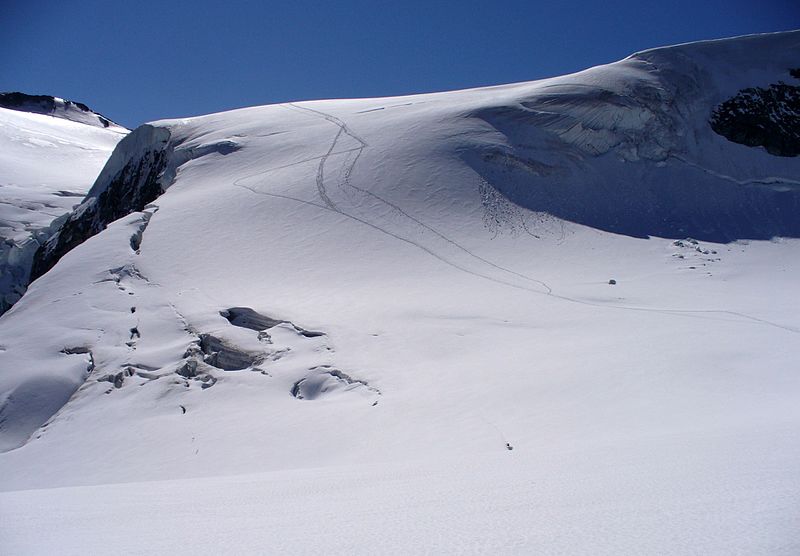
Pigne d'Arolla
#260 among destinations in Switzerland
![Pigne d'Arolla location map](https://tzmedia.b-cdn.net/media/images/static-maps/ch/45_9913_7_45515.jpg)
![Pigne d'Arolla](https://tzmedia.b-cdn.net/media/images/ch/place/gallery/medium/76ab1ec594f17552200ee47238660071.jpg)
Facts and practical information
Pigne d'Arolla is a mountain in the Pennine Alps in Switzerland. The first ascent was made by A. W. Moore and Horace Walker with the guide Jakob Anderegg on 9 July 1865. It is commonly climbed as part of the Haute Route. ()
ValaisSwitzerland
Pigne d'Arolla plan & book
Unleash the traveler in you — discover the cheapest flight deals, find the perfect hotel or hostel nearby, and search for the best car rental prices. Travel at your own pace to discover new places and enjoy your journey.
Pigne d'Arolla – popular in the area (distance from the attraction)
Nearby attractions include: Mont Blanc de Cheilon, Bertol Hut, Vignettes Hut, Aiguille de la Tsa.
1.8 miWNature, Natural attraction, MountainMont Blanc de Cheilon
47 min walk • Mont Blanc de Cheilon is a mountain of the Pennine Alps, located in the Swiss canton of Valais. The mountain lies between the valleys of Bagnes and Arolla.
3.6 miEAlpine hut, HikingBertol Hut
93 min walk • The Bertol Hut is a mountain hut overlooking the Bertol Pass, south of Arolla in the Swiss canton of Valais. It is known for its precarious position on a ridge at 3,311 metres south of the Pointe de Bertol and is accessed by a number of fixed ladders and chains from the glacier pass. All accesses to the hut involve glacier crossing.
1 miEAlpine hut, HikingVignettes Hut
26 min walk • The Vignettes Hut is an alpine hut, located south of Arolla in the Swiss canton of Valais. It lies at a height of 3,160 metres above sea level, at the foot of the Pigne d'Arolla and near the Col de Chermotane in the Pennine Alps.
3.8 miNENature, Natural attraction, MountainAiguille de la Tsa
98 min walk • The Aiguille de la Tsa is a mountain of the Swiss Pennine Alps, overlooking Arolla in the canton of Valais. It lies on the range culminating at the Dent de Perroc, between the valley of Arolla and the Mont Miné Glacier.
2.9 miSENature, Natural attraction, MountainL'Evêque
76 min walk • L'Evêque is a mountain of the Pennine Alps, overlooking the Col Collon in the canton of Valais, south of Mont Collon. With a height of 3,716 meters above sea level, it is one of the highest summits in the Arolla valley.
2.8 miWNature, Natural attraction, MountainLa Ruinette
71 min walk • La Ruinette is a mountain of the Swiss Pennine Alps, overlooking the Lake of Mauvoisin in the canton of Valais. With an altitude of 3,875 metres above sea level, it is the highest summit between the Grand Combin and the Dent Blanche.
3.5 miWNature, Natural attraction, MountainLa Luette
90 min walk • La Luette is a mountain of the Pennine Alps, located between the valleys of Bagnes and Hérens in the canton of Valais. It lies just south of Le Pleureur.
2.7 miENature, Natural attraction, MountainMont Collon
69 min walk • Mont Collon is a mountain of the Swiss Pennine Alps in the canton of Valais. Its glaciated north face dominates the view south from the village of Arolla. The ascent over the West Ridge, first made by A. Cust and F. Gardiner with the guides Peter Knubel and Johannes Knubel of St.
3.7 miENature, Natural attraction, MountainPointe de Bertol
95 min walk • The Pointe de Bertol is a mountain of the Swiss Pennine Alps, located south of Arolla in the canton of Valais. Its southern side overlooks the Bertol Pass. The Bertol Hut is located at the southern base of the peak.
3.2 miNNature, Natural attraction, MountainLa Cassorte
82 min walk • La Cassorte is a mountain of the Swiss Pennine Alps, located west of Arolla in the canton of Valais. It lies on the range between the Lac des Dix and the Val d'Arolla, south of the Aiguilles Rouges d'Arolla.
2.3 miNWAlpine hut, HikingDix Hut
58 min walk • The Dix Hut is a mountain hut of the Swiss Alpine Club, located south of Hérémence in the canton of Valais. The hut lies above the Cheilon Glacier, at a height of 2,928 metres above sea level, approximately halfway between the Lac des Dix and the Mont Blanc de Cheilon.