Klein Furkahorn
#1255 among destinations in Switzerland
Facts and practical information
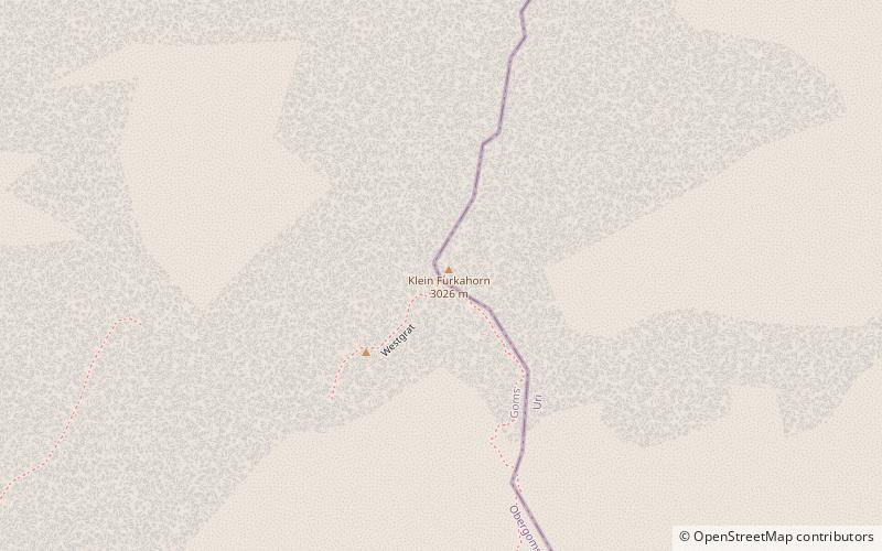
The Klein Furkahorn is a mountain of the Urner Alps, overlooking the Furka Pass on the border between the Swiss cantons of Valais and Uri. It lies near the southern end of the Galenstock-Gross Furkahorn chain, east of the Rhone Glacier. ()
ValaisSwitzerland
Klein Furkahorn plan & book
Unleash the traveler in you — discover the cheapest flight deals, find the perfect hotel or hostel nearby, and search for the best car rental prices. Travel at your own pace to discover new places and enjoy your journey.
Klein Furkahorn – popular in the area (distance from the attraction)
Nearby attractions include: Gelmersee, Totesee, Räterichsbodensee, Galenstock.
- 4.2 miNWNature, Natural attraction, Lake
Gelmersee
107 min walk • Nestled in the heart of the Swiss Alps, Gelmersee is a breathtaking mountain lake that offers a serene escape amidst nature's pristine beauty. With its crystal-clear turquoise waters, the lake is a hidden gem located near the Grimsel Pass in the canton of Bern...
- 3.6 miSWNature, Natural attraction, Lake
Totesee
92 min walk • Totesee is a small natural lake at the Grimsel Pass in Switzerland. The lake lies immediately to the south of the natural watershed and cantonal boundary at the pass.
- 3.7 miWNature, Natural attraction, Lake
Räterichsbodensee
95 min walk • Räterichsbodensee is a lake in Guttannen, Oberhasli, Switzerland. The reservoir has a volume of 25 mio m³, a surface area is 0.67 km² and is operated by Kraftwerke Oberhasli. It is connected to the river Aare.
- 1.9 miNNature, Natural attraction, Mountain
Galenstock
49 min walk • The Galenstock is the fourth highest mountain in the Urner Alps in Switzerland. Its summit ridge lies on the border between the cantons of Uri and the Valais.
- 3.6 miSWNature, Natural attraction, Mountain pass
Hotel Grimsel Passhöhe
93 min walk • The Grimsel Pass is a mountain pass in Switzerland, crossing the Bernese Alps at an elevation of 2,164 metres. The pass connects the Haslital, the upper valley of the river Aare, with the upper valley of the Rhône.
- 2.9 miSNature, Natural attraction, Mountain
Muttenhorn
74 min walk • The Muttenhorn is a mountain in the Lepontine Alps, located on the border between the cantons of Valais and Uri. At 3,099 metres above sea level, it overlooks the south side of Furka Pass.
- 4 miNNature, Natural attraction, Mountain
Dammastock
104 min walk • The Dammastock is the highest mountain in the Urner Alps in Switzerland and is part of the Winterberg massif. Its summit ridge forms the border between the cantons of Uri and the Valais. It is the highest summit in the canton of Uri.
- 3.3 miNENature, Natural attraction, Mountain
Winterstock
84 min walk • The Winterstock is a mountain of the Urner Alps, located west of Realp in the canton of Uri. It lies on the range east of the Tiefenstock, that separates the Göschenertal from the valley called Urseren.
- 4.4 miNNature, Natural attraction, Mountain
Schneestock
111 min walk • The Schneestock is a mountain of the Urner Alps, located on the border between the Swiss cantons of Valais and Uri. It lies north of the Dammastock, between the Rhone Glacier and the Damma Glacier.
- 0.8 miNNature, Natural attraction, Mountain
Gross Furkahorn
20 min walk • The Gross Furkahorn is a mountain of the Urner Alps, located on the border between the Swiss cantons of Valais and Uri. It lies north of the Furka Pass and east of the Rhone Glacier.
- 1.7 miSWNature, Natural attraction, Natural feature
Rhône Glacier
44 min walk • The Rhône Glacier is a glacier in the Swiss Alps and the source of the river Rhône and one of the primary contributors to Lake Geneva in the far eastern end of the Swiss canton of Valais. Because the glacier is located close to the Furka Pass road it is easily accessible.