Oberrothorn, Zermatt
#14 among attractions in Zermatt
Facts and practical information
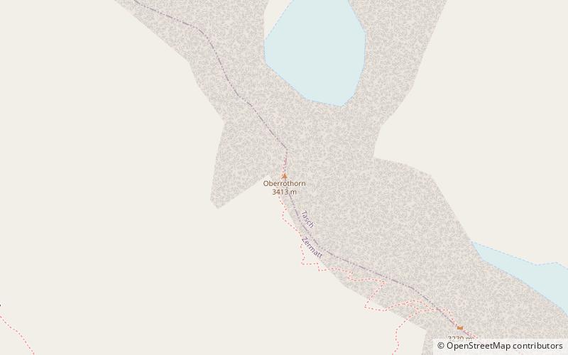
The Oberrothorn is a mountain of the Swiss Pennine Alps, overlooking Zermatt in the canton of Valais. Its summit can be easily reached via a trail on its southern flank, from the Unterrothorn cable car station or from Sunnegga. ()
Zermatt Switzerland
Zermatt plan & book
Unleash the traveler in you — discover the cheapest flight deals, find the perfect hotel or hostel nearby, and search for the best car rental prices. Travel at your own pace to discover new places and enjoy your journey.
Oberrothorn – popular in the area (distance from the attraction)
Nearby attractions include: Gornergrat, Riffelsee, Matterhorn Museum, Unterrothorn.
- 3.3 miSWRidge with a cog railway and scenic views
Gornergrat, Zermatt
86 min walk • Gornergrat stands as a majestic mountain ridge in the Swiss Alps, offering one of the most stunning panoramic views in the city of Zermatt, Switzerland. At an elevation of 3,089 meters, Gornergrat has been a magnet for mountaineers, skiers, and tourists seeking to bask...
- 3.9 miSWAlpine lake with Matterhorn views
Riffelsee, Zermatt
100 min walk • Nestled in the shadow of the iconic Matterhorn, Riffelsee is a serene alpine lake that offers one of the most breathtaking reflections of the famed mountain in Zermatt, Switzerland. This picturesque body of water is situated at an elevation of 2,757 meters above sea...
- 3.2 miWMuseum, History museum
Matterhorn Museum, Zermatt
83 min walk • The Matterhorn Museum in Zermatt is a cultural-natural museum whose main theme is the Matterhorn.
- 0.8 miSWGrand mountain with a cable car
Unterrothorn, Zermatt
22 min walk • The Unterrothon is a mountain of the Swiss Pennine Alps, overlooking Zermatt in the canton of Valais. It is located west of the Oberrothorn, on the range north of the Findel Glacier. The summit can be reached by cable car via Sunnegga and Blauherd. The Rothorn paradise is one of the main ski areas located around Zermatt.
- 3.6 miW46°0'45"N • 7°44'26"E
Forest Fun Park Zermatt, Zermatt
93 min walk • Climbing, Adrenaline and extreme tours, Adventure park
- 3.9 miNWNatural attraction, Mountain, Park
Mettelhorn, Zermatt
101 min walk • The Mettelhorn is a mountain of the Swiss Pennine Alps, located near Zermatt in the canton of Valais. The Mettelhorn provides excellent acclimatization opportunities, especially if one climbs its sister peaks Platthorn and Wisshorn on the same day.
- 2 miSWNatural attraction, Lake, Body of water
Grünsee, Zermatt
51 min walk • The Grünsee is a small lake near Zermatt, Switzerland, which is fed by the Findel Glacier. It is quite remote and is only accessible by foot, a small hub of the many footpaths in the area. There is a small hamlet nearby of the same name.
- 3.5 miNENature, Natural attraction, Mountain
Alphubel
89 min walk • The Alphubel is a mountain of the Swiss Pennine Alps, located between the valleys of Zermatt and Saas in the canton of Valais. It is part of the Allalin Group, a subgroup of the Mischabel Group, which culminates at the Dom.
- 3.7 miNENature, Natural attraction, Mountain
Feechopf
94 min walk • The Feechopf is a mountain of the Swiss Pennine Alps, located near Saas Fee in the canton of Valais. It lies between the Alphubel and the Allalinhorn.
- 3.4 miENature, Natural attraction, Mountain
Rimpfischhorn
88 min walk • The Rimpfischhorn is a mountain in the Pennine Alps of Switzerland. The first ascent of the mountain was by Leslie Stephen and Robert Living with guides Melchior Anderegg and Johann Zumtaugwald on 9 September 1859. Their route of ascent was from Fluh Alp via the Rimpfischwänge.
- 2.7 miSNature, Natural attraction, Mountain
Hohtälli
69 min walk • The Hohtälli is a mountain of the Swiss Pennine Alps, located southeast of Zermatt in the canton of Valais. It lies on the range that separates the Findel Glacier from the Gorner Glacier, between the Gornergrat and the Stockhorn.