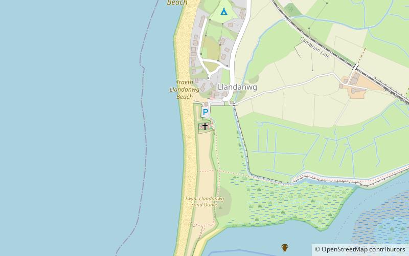
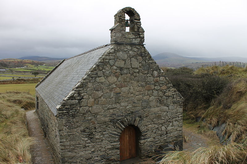
St Tanwg's Church, Snowdonia National Park
#15 among attractions in Snowdonia National Park
Facts and practical information
St Tanwg's Church, Llandanwg, also known as "the church in the sand", is an early medieval church dedicated to St Tanwg in the village of Llandanwg, Gwynedd, Wales. The church is a Grade I listed building. ()
- Train
- Train
- Calculate routeLlandanwg 7 min walkLines no data
- Calculate routePensarn 17 min walkLines no data
- Calculate routeLlanbedr 28 min walkLines no data
Snowdonia National Park plan & book
Unleash the traveler in you — discover the cheapest flight deals, find the perfect hotel or hostel nearby, and search for the best car rental prices. Travel at your own pace to discover new places and enjoy your journey.
St Tanwg's Church – popular in the area (distance from the attraction)
Nearby attractions include: Harlech Castle, Bryn Cader Faner, Moel Ysgyfarnogod, Moelfre Hill.
2 miN Imposing medieval stronghold of Edward IHarlech Castle, Harlech
52 min walk • Harlech Castle is a majestic medieval fortification located in the coastal town of Harlech, within the scenic landscape of North Wales, United Kingdom. Perched high on a rocky outcrop, it offers breathtaking views of the Irish Sea and the surrounding countryside...
- 6.6 miNEMemorial
Bryn Cader Faner, Snowdonia National Park
168 min walk • Bryn Cader Faner is a Bronze Age round cairn which lies to the east of the small hamlet of Talsarnau in the Ardudwy area of Gwynedd in Wales. The diameter is 8.7 metres and there are 18 thin jagged pillars which jut upwards from the low cairn. It is thought to date back to the late third millennium BC.
- 6.8 miNENature, Natural attraction, Mountain
Moel Ysgyfarnogod, Snowdonia National Park
175 min walk • Moel Ysgyfarnogod is a mountain in Snowdonia, North Wales and is the northernmost of the Rhinogydd. Rhinog Fawr lies directly south. It overlooks Llyn Trawsfynydd, and from the summit it is possible to see the towns of Porthmadog and Blaenau Ffestiniog. It may be climbed from Trawsfynydd in the east, or from Talsarnau in the west.
- 4.2 miSENature, Natural attraction, Mountain
Moelfre Hill, Snowdonia National Park
108 min walk • Moelfre is a hill in Wales on the far western edge of the Snowdonia National Park, 3 miles from the village of Dyffryn Ardudwy, 5 miles from the village of Llanbedr and about 10 miles from the town of Harlech. It forms part of the Rhinogydd range. Moelfre reaches a height of 589 metres.
- 3.8 miSChurch
St Dwywe's Church, Snowdonia National Park
98 min walk • St Dwywe’s Church is a Grade II* listed church in Llanddwywe, Gwynedd, North Wales. It has a curvilinear churchyard and farm buildings on its west. Its structure, of rubble stone construction, is mainly of late medieval and early modern date, the church having first been mentioned in documents dating to 1292–1293.
- 5.8 miNArea
Ynys Gifftan, Snowdonia National Park
149 min walk • Ynys Gifftan is an island near the south east shore of Traeth Bach, the Dwyryd estuary near Portmeirion in Gwynedd, north Wales. There is a public footpath to it across the estuary marked on Ordnance Survey maps but has no definable marks that make it obvious; it can be reached on foot at low tide and is 38 metres high.
- 2.2 miEChurch
Capel Salem, Snowdonia National Park
56 min walk • Capel Salem is a Grade II listed building in the hamlet of Pentre Gwynfryn, near Llanbedr, Gwynedd, Wales. This Baptist chapel building is located about a mile up river of Llanbedr, on a ridge between the two valleys. It is just 300 yards upstream from where the two rivers meet.
- 5.3 miENature, Natural attraction, Mountain
Rhinogydd, Snowdonia National Park
135 min walk • The Rhinogydd are a range of mountains located east of Harlech in North Wales. The name Rhinogydd derives from the names of two of the more famous peaks, Rhinog Fawr and Rhinog Fach, although the greatest elevation in the range is reached by Y Llethr, 756 m.
- 4.6 miNENature, Natural attraction, Lake
Llyn Cwm Bychan, Snowdonia National Park
118 min walk • Llyn Cwm Bychan is a lake in north Wales, and is one of the sources of the River Artro which flows south westwards through Llanbedr and onwards to the sea. It is located in the Rhinogydd mountains of Snowdonia.
- 2.1 miNStreet
Ffordd Pen Llech, Snowdonia National Park
54 min walk • Ffordd Pen Llech is a public road in the town of Harlech which lies within Snowdonia National Park, North Wales. It was once considered the steepest street in the world, although that title reverted to the previous holder Baldwin Street on 8 April 2020.
- 2.7 miSNatural attraction, Protected area
Morfa Dyffryn, Snowdonia National Park
70 min walk • Morfa Dyffryn beach is on the west coast of Wales, between Barmouth and Harlech in Gwynedd. This sandy beach is several miles long and is chiefly known for having an officially recognised naturist area, 1 kilometre in length. The beach is very clean and is also known for regular sightings of dolphins.
Frequently Asked Questions (FAQ)
How to get to St Tanwg's Church by public transport?
Train
- Llandanwg (7 min walk)
- Pensarn (17 min walk)