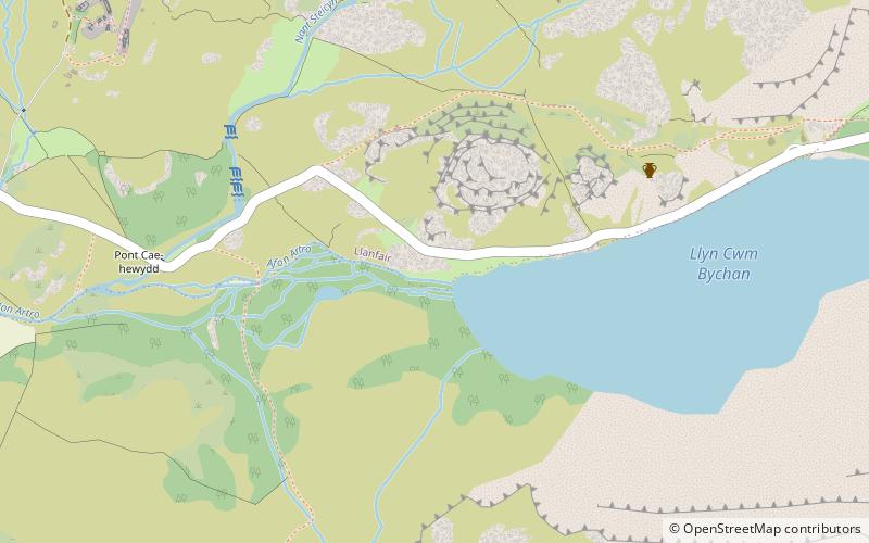
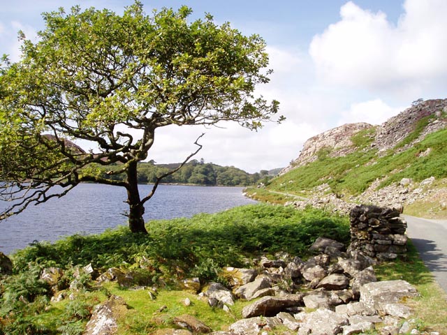
Llyn Cwm Bychan, Snowdonia National Park
#115 among attractions in Snowdonia National Park

Facts and practical information
Llyn Cwm Bychan is a lake in north Wales, and is one of the sources of the River Artro which flows south westwards through Llanbedr and onwards to the sea. It is located in the Rhinogydd mountains of Snowdonia. ()
Snowdonia National Park United Kingdom
Snowdonia National Park plan & book
Unleash the traveler in you — discover the cheapest flight deals, find the perfect hotel or hostel nearby, and search for the best car rental prices. Travel at your own pace to discover new places and enjoy your journey.
Llyn Cwm Bychan – popular in the area (distance from the attraction)
Nearby attractions include: Harlech Castle, St Tanwg's Church, Pont Briwet, Bryn Cader Faner.

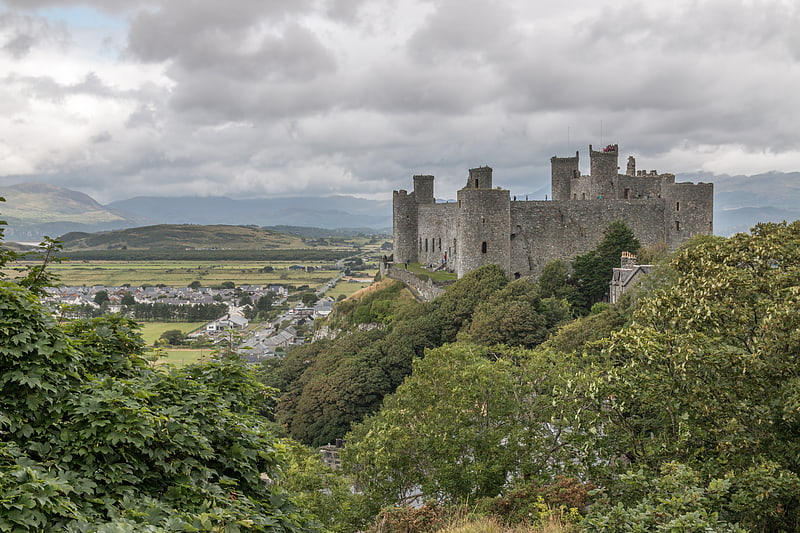
3.4 miW Imposing medieval stronghold of Edward IHarlech Castle, Harlech
88 min walk • Harlech Castle is a majestic medieval fortification located in the coastal town of Harlech, within the scenic landscape of North Wales, United Kingdom. Perched high on a rocky outcrop, it offers breathtaking views of the Irish Sea and the surrounding countryside...
 Church
St Tanwg's Church, Snowdonia National Park
118 min walk • St Tanwg's Church, Llandanwg, also known as "the church in the sand", is an early medieval church dedicated to St Tanwg in the village of Llandanwg, Gwynedd, Wales. The church is a Grade I listed building.
 Bridge
Pont Briwet, Penrhyndeudraeth
115 min walk • Pont Briwet refers to the road and railway bridges that cross the River Dwyryd, near Penrhyndeudraeth, Gwynedd in North Wales. The first bridge was a Victorian road and railway viaduct that was constructed entirely from timber by the Cambrian Railways company.
 Memorial
Bryn Cader Faner, Snowdonia National Park
67 min walk • Bryn Cader Faner is a Bronze Age round cairn which lies to the east of the small hamlet of Talsarnau in the Ardudwy area of Gwynedd in Wales. The diameter is 8.7 metres and there are 18 thin jagged pillars which jut upwards from the low cairn. It is thought to date back to the late third millennium BC.
 Nature, Natural attraction, Mountain
Moel Ysgyfarnogod, Snowdonia National Park
64 min walk • Moel Ysgyfarnogod is a mountain in Snowdonia, North Wales and is the northernmost of the Rhinogydd. Rhinog Fawr lies directly south. It overlooks Llyn Trawsfynydd, and from the summit it is possible to see the towns of Porthmadog and Blaenau Ffestiniog. It may be climbed from Trawsfynydd in the east, or from Talsarnau in the west.
 Nature, Natural attraction, Mountain
Moelfre Hill, Snowdonia National Park
108 min walk • Moelfre is a hill in Wales on the far western edge of the Snowdonia National Park, 3 miles from the village of Dyffryn Ardudwy, 5 miles from the village of Llanbedr and about 10 miles from the town of Harlech. It forms part of the Rhinogydd range. Moelfre reaches a height of 589 metres.
 Area
AreaYnys Gifftan, Snowdonia National Park
108 min walk • Ynys Gifftan is an island near the south east shore of Traeth Bach, the Dwyryd estuary near Portmeirion in Gwynedd, north Wales. There is a public footpath to it across the estuary marked on Ordnance Survey maps but has no definable marks that make it obvious; it can be reached on foot at low tide and is 38 metres high.
 Church
Capel Salem, Snowdonia National Park
82 min walk • Capel Salem is a Grade II listed building in the hamlet of Pentre Gwynfryn, near Llanbedr, Gwynedd, Wales. This Baptist chapel building is located about a mile up river of Llanbedr, on a ridge between the two valleys. It is just 300 yards upstream from where the two rivers meet.
 Nature, Natural attraction, Mountain
Rhinog Fawr, Snowdonia National Park
57 min walk • Rhinog Fawr is a mountain in Snowdonia, North Wales and forms part of the Rhinogydd range. It is the third highest summit of the Rhinogydd, losing out to Y Llethr and Diffwys respectively.
 Nature, Natural attraction, Mountain
Rhinogydd, Snowdonia National Park
26 min walk • The Rhinogydd are a range of mountains located east of Harlech in North Wales. The name Rhinogydd derives from the names of two of the more famous peaks, Rhinog Fawr and Rhinog Fach, although the greatest elevation in the range is reached by Y Llethr, 756 m.
 Nature, Natural attraction, Mountain
Y Llethr, Snowdonia National Park
96 min walk • Y Llethr is the highest mountain in the Rhinogydd range of Snowdonia, in north Wales. The summit consists of a flat grassy top marked only by a small cairn. The summit is more in keeping with its southern flanks than its rugged northern approach.