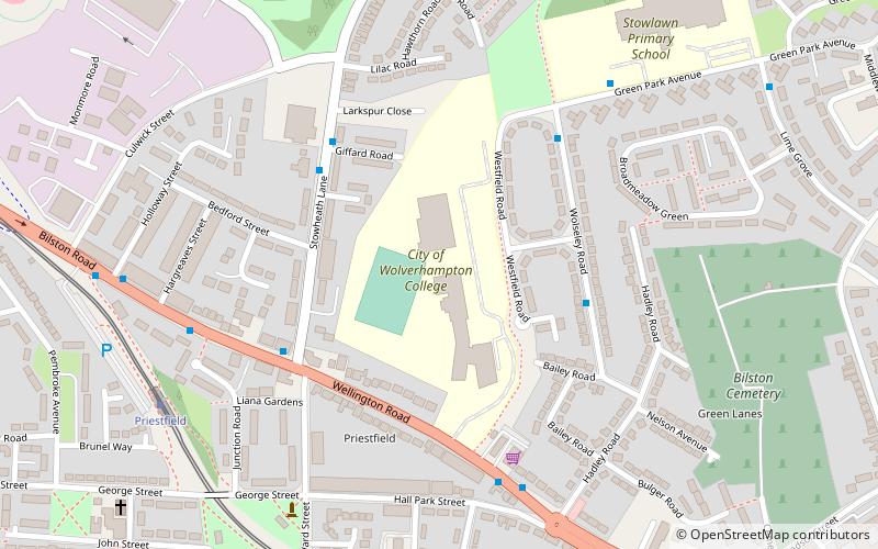
City of Wolverhampton College, Wolverhampton
Map
Facts and practical information
City of Wolverhampton College is a further education college located in Wolverhampton, West Midlands, England. ()
Coordinates: 52°34'25"N, 2°5'33"W
Getting there by public transportation
Public transportation stops near this location
- Bus
- Tram
- Train
 Bus
Bus
- Calculate routeWolseley Rd / Lambeth Rd 4 min walk
- Calculate routeStowheath Lane / Giffard Rd 4 min walk
- Calculate routeBilston Rd / Stow Heath Lane 5 min walk
- Calculate routePriestfield 7 min walk
- Calculate routeThe Crescent 16 min walk
- Calculate routeBilston Central 24 min walk
- Calculate routeThe Royal 30 min walk
- Calculate routeWolverhampton 39 min walk
Day trips


Frequently Asked Questions (FAQ)
Which popular attractions are close to City of Wolverhampton College?
Nearby attractions include East Park, Wolverhampton (16 min walk), St Matthew's Church, Wolverhampton (18 min walk), Bilston, Wolverhampton (23 min walk), Bilston Town Hall, Wolverhampton (24 min walk).
How to get to City of Wolverhampton College by public transport?
The nearest stations to City of Wolverhampton College:
Bus
Tram
Train
Bus
- Wolseley Rd / Lambeth Rd • Lines: 23 (4 min walk)
- Stowheath Lane / Giffard Rd • Lines: 53 (4 min walk)
Tram
- Priestfield • Lines: 1 (7 min walk)
- The Crescent • Lines: 1 (16 min walk)
Train
- Wolverhampton (39 min walk)