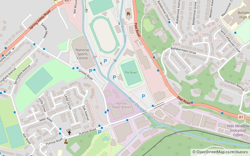
The Bowl, Douglas
Map
Facts and practical information
The King George V Bowl is a multi-use stadium in Douglas, Isle of Man, and the home of F.C. Isle of Man. With a capacity of approximately 3,000 seats, a third of which are under cover, and a viewing platform for disabled users, it is the largest stadium on the Island. The Bowl also serves as the home of the Isle of Man Football Association, Isle of Man official football team and Ellan Vannin football team. ()
Address
Douglas
ContactAdd
Social media
Add
Getting there by public transportation
Public transportation stops near this location
- Bus
- Tram
- Train
 Bus
Bus
- Calculate routeNational Sports Centre Layby 4 min walk
- Calculate routeGroves Road / National Sports Centre 4 min walk
- Calculate routeVictoria Street 25 min walk
- Calculate routeLoch Promenade 25 min walk
- Calculate routeDouglas Railway Station 19 min walk
- Calculate routeGranville Street 25 min walk
- Calculate routeLoch Promanade / Howard Street 25 min walk
- Calculate routeThe Sefton Hotel 25 min walk
Day trips


Frequently Asked Questions (FAQ)
Which popular attractions are close to The Bowl?
Nearby attractions include Priory of Douglas, Douglas (10 min walk), All Saints Church, Douglas (15 min walk), Mobile Family Library, Douglas (17 min walk), St. Mary of the Isle Church, Douglas (20 min walk).
How to get to The Bowl by public transport?
The nearest stations to The Bowl:
Bus
Train
Tram
Bus
- National Sports Centre Layby • Lines: 1 (4 min walk)
- Groves Road / National Sports Centre • Lines: 1 (4 min walk)
Train
- Douglas Railway Station (19 min walk)
Tram
- Granville Street • Lines: Douglas Horse Tramway (25 min walk)
- Loch Promanade / Howard Street • Lines: Douglas Horse Tramway (25 min walk)