Redfield, Bristol
Map
Facts and practical information
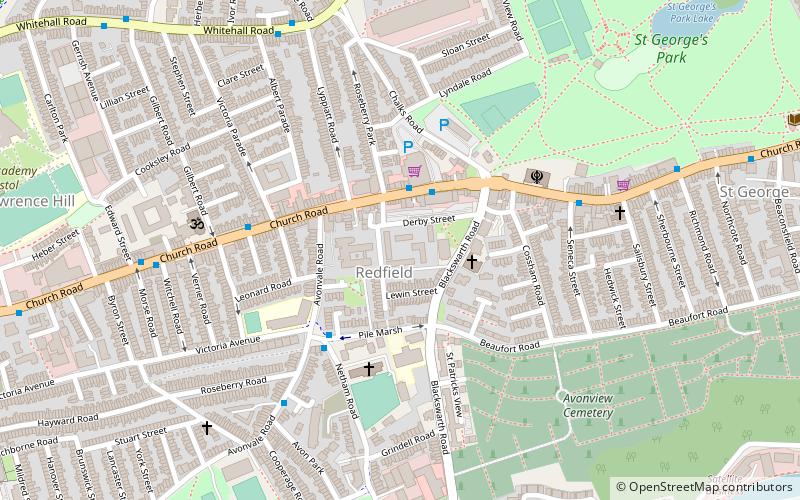
Redfield is an area situated in East Bristol though it is represented in Westminster as part of the Bristol West constituency. It includes the stretch of Church Road from Verrier Road to the western boundary of St George's Green, Victorian-era landscaped parkland. It is adjacent to the neighbourhoods of Barton Hill and Russell Town to the South, St George to the East, Whitehall to the North and Lawrence Hill to the West and Pile Marsh to the South-East. ()
Coordinates: 51°27'32"N, 2°33'10"W
Address
St. George WestBristol
ContactAdd
Social media
Add
Getting there by public transportation
Public transportation stops near this location
- Bus
- Train
 Bus
Bus
- Calculate routeBlackswarth Road 2 min walk
- Calculate routeGilbert Road 4 min walk
- Calculate routeSeneca Street 5 min walk
- Calculate routeEdward Street 6 min walk
- Calculate routeLawrence Hill 13 min walk
- Calculate routeStapleton Road 22 min walk
Day trips


Frequently Asked Questions (FAQ)
Which popular attractions are close to Redfield?
Nearby attractions include St George's Park, Bristol (8 min walk), Netham Lock, Bristol (13 min walk), Avon Bridge, Bristol (17 min walk), Barton Hill, Bristol (19 min walk).
How to get to Redfield by public transport?
The nearest stations to Redfield:
Bus
Train
Bus
- Blackswarth Road • Lines: 43 (2 min walk)
- Gilbert Road • Lines: 43 (4 min walk)
Train
- Lawrence Hill (13 min walk)
- Stapleton Road (22 min walk)