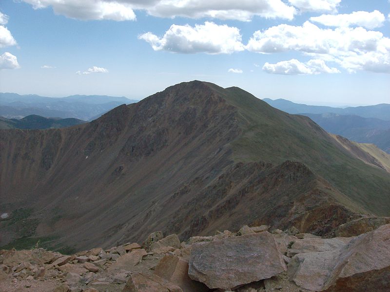
Bard Peak, Arapaho National Forest
#10 among attractions in Arapaho National Forest
Facts and practical information
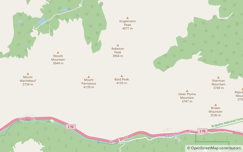
Bard Peak is a high and prominent mountain summit in the Front Range of the Rocky Mountains of North America. The 13,647-foot thirteener is located in Arapaho National Forest, 4.5 miles west-northwest of the Town of Silver Plume in Clear Creek County, Colorado, United States. ()
Arapaho National Forest United States
Arapaho National Forest plan & book
Unleash the traveler in you — discover the cheapest flight deals, find the perfect hotel or hostel nearby, and search for the best car rental prices. Travel at your own pace to discover new places and enjoy your journey.
Bard Peak – popular in the area (distance from the attraction)
Nearby attractions include: Loveland Ski Area, Pass Lake, Torreys Peak, Grizzly Peak.
- 5.7 miSWWinter sport, Ski area
Loveland Ski Area, Arapaho National Forest
145 min walk • Loveland Ski Area is a ski area in the western United States, located near the town of Georgetown, Colorado. Located at the eastern portal of the Eisenhower Tunnel, Loveland is within the Arapahoe National Forest.
- 6 miSWLake
Pass Lake, Arapahoe Basin
154 min walk • Pass Lake is a small lake located south of Loveland Pass in Summit County, Colorado. Pass Lake drains east via an unnamed stream which flows into North Fork Snake River. The Pass Lake Picnic Area is located by the lake.
- 5.4 miSNature, Natural attraction, Mountain
Torreys Peak, Arapaho National Forest
139 min walk • Torreys Peak is a mountain in the Front Range region of the Rocky Mountains in Colorado. It is one of 53 fourteeners in Colorado. Its nearest major city is Denver. Torreys Peak is located along the Continental Divide, as well as the division between Clear Creek County and Summit County.
- 5.8 miSWNature, Natural attraction, Mountain
Grizzly Peak, Arapaho National Forest
147 min walk • Grizzly Peak is a high mountain summit in the Front Range of the Rocky Mountains of North America. Also known as Grizzly Peak D, the 13,433-foot thirteener is located in Arapaho National Forest, 2.1 miles southeast by east of Loveland Pass, Colorado, United States, on the Continental Divide between Clear Creek and Summit counties.
- 1 miWNature, Natural attraction, Mountain
Mount Parnassus, Arapaho National Forest
26 min walk • Mount Parnassus is a high mountain summit in the Front Range of the Rocky Mountains of North America. The 13,580-foot thirteener is located in Arapaho National Forest, 5.4 miles west-northwest of the Town of Silver Plume in Clear Creek County, Colorado, United States.
- 4.1 miSWNature, Natural attraction, Mountain
Mount Sniktau, Arapaho National Forest
104 min walk • Mount Sniktau is a high mountain summit in the Front Range of the Rocky Mountains of North America. The 13,240-foot thirteener is located in Arapaho National Forest, 1.6 miles northeast of Loveland Pass in Clear Creek County, Colorado, United States.
- 5.5 miSHiking, Hiking trail
Grays Peak Trail, Arapaho National Forest
140 min walk • Grays Peak National Recreation Trail or Grays Peak Trail lies along the Continental Divide of the Americas, part of the Rocky Mountains in the U.S. state of Colorado. It is located in the White River National Forest, Summit County. Grays Peak Trail is south of Interstate 70, east of Keystone Resort and near Montezuma.
- 1.7 miNNature, Natural attraction, Mountain
Engelmann Peak, Arapaho National Forest
45 min walk • Engelmann Peak is a high mountain summit in the Front Range of the Rocky Mountains of North America. The 13,368-foot thirteener is located in Arapaho National Forest, 6.3 miles west by south of the Town of Empire in Clear Creek County, Colorado, United States.
- 5.5 miEGothic Revival architecture
Toll House, Georgetown
140 min walk • The Toll House is a residence in Clear Creek County, Colorado. It was built by 1878 near the toll gates of a private road linking mines between the towns of Silver Plume, Colorado and Georgetown, Colorado. The home belonged to Julius G.
- 5.6 miSWView point
Loveland Pass, Keystone
142 min walk • Loveland Pass is a high mountain pass in north-central Colorado, at an elevation of 11,990 feet above sea level in the Rocky Mountains of the Western United States.
- 5.8 miNWMountain pass, Nature
Jones Pass, Arapaho National Forest
149 min walk • Jones Pass, elevation 12,454 ft, is a mountain pass that crosses the Continental Divide in the Front Range of the Rocky Mountains of Colorado in the United States.