Pass Lake, Arapahoe Basin
#1 among attractions in Arapahoe Basin
Facts and practical information
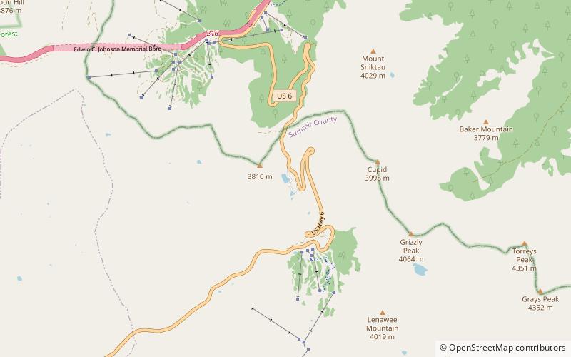
Pass Lake is a small lake located south of Loveland Pass in Summit County, Colorado. Pass Lake drains east via an unnamed stream which flows into North Fork Snake River. The Pass Lake Picnic Area is located by the lake. ()
Arapahoe Basin United States
Pass Lake – popular in the area (distance from the attraction)
Nearby attractions include: Loveland Ski Area, Grays Peak, Torreys Peak, American Discovery Trail.
 Winter sport, Ski area
Loveland Ski Area, Arapaho National Forest
51 min walk • Loveland Ski Area is a ski area in the western United States, located near the town of Georgetown, Colorado. Located at the eastern portal of the Eisenhower Tunnel, Loveland is within the Arapahoe National Forest.
 Nature, Natural attraction, Mountain
Grays Peak, Arapaho National Forest
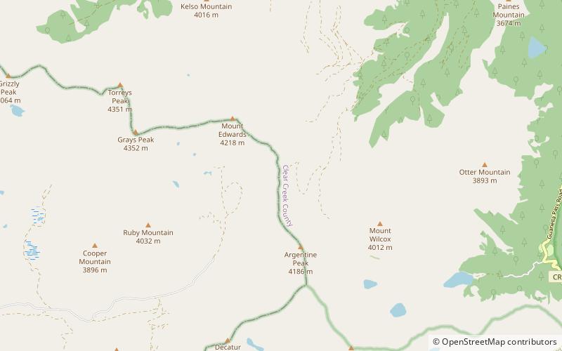
91 min walk • Grays Peak is the tenth-highest summit of the Rocky Mountains of North America and the U.S. state of Colorado. The prominent 14,278-foot fourteener is the highest summit of the Front Range and the highest point on the Continental Divide and the Continental Divide Trail in North America.
 Nature, Natural attraction, Mountain
Torreys Peak, Arapaho National Forest
82 min walk • Torreys Peak is a mountain in the Front Range region of the Rocky Mountains in Colorado. It is one of 53 fourteeners in Colorado. Its nearest major city is Denver. Torreys Peak is located along the Continental Divide, as well as the division between Clear Creek County and Summit County.
 Hiking, Hiking trail
American Discovery Trail, Arapaho National Forest
141 min walk • The American Discovery Trail is a system of recreational trails and roads which collectively form a coast-to-coast hiking and biking trail across the mid-tier of the United States. Horses can also be ridden on most of this trail.
 Nature, Natural attraction, Mountain
Grizzly Peak, Arapaho National Forest
45 min walk • Grizzly Peak is a high mountain summit in the Front Range of the Rocky Mountains of North America. Also known as Grizzly Peak D, the 13,433-foot thirteener is located in Arapaho National Forest, 2.1 miles southeast by east of Loveland Pass, Colorado, United States, on the Continental Divide between Clear Creek and Summit counties.
 Nature, Natural attraction, Mountain
Mount Parnassus, Arapaho National Forest
138 min walk • Mount Parnassus is a high mountain summit in the Front Range of the Rocky Mountains of North America. The 13,580-foot thirteener is located in Arapaho National Forest, 5.4 miles west-northwest of the Town of Silver Plume in Clear Creek County, Colorado, United States.
 Nature, Natural attraction, Mountain
Mount Sniktau, Arapaho National Forest
51 min walk • Mount Sniktau is a high mountain summit in the Front Range of the Rocky Mountains of North America. The 13,240-foot thirteener is located in Arapaho National Forest, 1.6 miles northeast of Loveland Pass in Clear Creek County, Colorado, United States.
 Nature, Natural attraction, Mountain
Bard Peak, Arapaho National Forest
154 min walk • Bard Peak is a high and prominent mountain summit in the Front Range of the Rocky Mountains of North America. The 13,647-foot thirteener is located in Arapaho National Forest, 4.5 miles west-northwest of the Town of Silver Plume in Clear Creek County, Colorado, United States.
 Hiking, Hiking trail
Grays Peak Trail, Arapaho National Forest
95 min walk • Grays Peak National Recreation Trail or Grays Peak Trail lies along the Continental Divide of the Americas, part of the Rocky Mountains in the U.S. state of Colorado. It is located in the White River National Forest, Summit County. Grays Peak Trail is south of Interstate 70, east of Keystone Resort and near Montezuma.
 Nature, Canyon
Clear Creek, Arapaho National Forest
70 min walk • Clear Creek is a tributary of the South Platte River, approximately 66 miles long, in north central Colorado in the United States.
 Nature, Natural attraction, Mountain
Mount Edwards, Arapaho National Forest
120 min walk • Mount Edwards is a high mountain summit in the Rocky Mountains' Front Range of North America. The 13,856-foot thirteener is located in Arapaho National Forest, 7.6 miles southwest of the Town of Georgetown, Colorado, United States, on the Continental Divide between Clear Creek and Summit counties.


