Watsessing Park, Bloomfield
Map
Facts and practical information
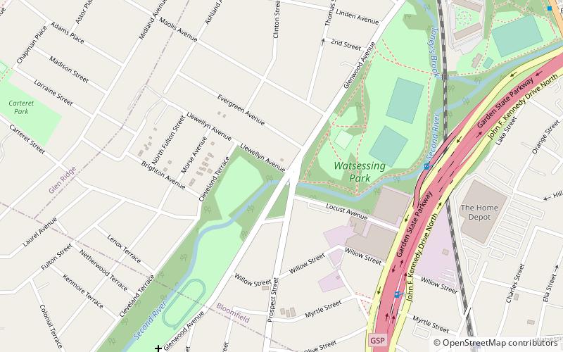
Watsessing Park is a park in Essex County, New Jersey, in the city of East Orange and the Watsessing section of Bloomfield Township. The park covers 69 acres, just west of the Garden State Parkway, and contains the confluence of the Second River and Toney's Brook. ()
Elevation: 118 ft a.s.l.Coordinates: 40°47'12"N, 74°12'15"W
Address
Glenwood AveWatsessing ParkBloomfield 07003
ContactAdd
Social media
Add
Getting there by public transportation
Public transportation stops near this location
- Bus
- Light rail
- Train
 Bus
Bus
- Calculate routeWatsessing Avenue 11 min walk
- Calculate routeBloomfield 13 min walk
- Calculate routeGlen Ridge 25 min walk
- Calculate routeBloomfield Avenue at Burroughs Place 13 min walk
- Calculate routeProspect Street at Springdale Avenue 23 min walk
- Calculate routeNJ Transit Depot & Maintenance Yard 26 min walk
- Calculate routeGrove Street 25 min walk
Day trips


Frequently Asked Questions (FAQ)
Which popular attractions are close to Watsessing Park?
Nearby attractions include Bloomfield College, Bloomfield (20 min walk), Bloomfield Green Historic District, Bloomfield (22 min walk).
How to get to Watsessing Park by public transport?
The nearest stations to Watsessing Park:
Train
Bus
Light rail
Train
- Watsessing Avenue (11 min walk)
- Bloomfield (13 min walk)
Bus
- Bloomfield Avenue at Burroughs Place • Lines: 94 (13 min walk)
- Prospect Street at Springdale Avenue • Lines: 94 (23 min walk)
Light rail
- Grove Street • Lines: Nlr (25 min walk)