Meiklejohn Stadium, Philadelphia
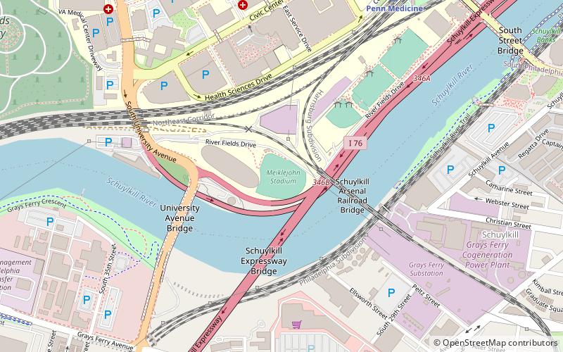
Map
Facts and practical information
Meiklejohn Stadium is a ballpark in Philadelphia, Pennsylvania. It is on the University of Pennsylvania campus and is the home field for the University of Pennsylvania Quakers varsity baseball team. It opened in March 2000. ()
Capacity: 850Coordinates: 39°56'37"N, 75°11'38"W
Address
West Philadelphia (University City)Philadelphia
ContactAdd
Social media
Add
Getting there by public transportation
Public transportation stops near this location
- Metro
- Bus
- Tram
- Train
 Metro
Metro
- Calculate routePenn Medicine 9 min walk
- Calculate routePhiladelphia 30th Street Station 27 min walk
- Calculate route37th Street 14 min walk
- Calculate route40th Street Portal 17 min walk
- Calculate route36th Street 19 min walk
- Calculate routeWoodland Avenue & 42nd Street 19 min walk
- Calculate route34th Street 22 min walk
- Calculate route30th Street 24 min walk
- Calculate route40th Street 27 min walk
- Calculate route46th Street 38 min walk
- Calculate routeMarket St & 39th St 25 min walk
- Calculate routeWalnut St & 23rd St 25 min walk
- Calculate routeMegabus 26 min walk
- Calculate routeBolt Bus 26 min walk
Maps SEPTA Regional Rail
SEPTA Regional RailDay trips


Frequently Asked Questions (FAQ)
Which popular attractions are close to Meiklejohn Stadium?
Nearby attractions include Schuylkill Arsenal Railroad Bridge, Philadelphia (5 min walk), University Avenue Bridge, Philadelphia (6 min walk), South Street Bridge, Philadelphia (7 min walk), University of Pennsylvania Campus Historic District, Philadelphia (10 min walk).
How to get to Meiklejohn Stadium by public transport?
The nearest stations to Meiklejohn Stadium:
Train
Tram
Metro
Bus
Train
- Penn Medicine (9 min walk)
- Philadelphia 30th Street Station (27 min walk)
Tram
- 37th Street • Lines: 11, 13, 34, 36 (14 min walk)
- 40th Street Portal • Lines: 11, 13, 34, 36 (17 min walk)
Metro
- 34th Street • Lines: Mfl (22 min walk)
- 30th Street • Lines: Mfl (24 min walk)
Bus
- Market St & 39th St • Lines: 40 (25 min walk)
- Walnut St & 23rd St • Lines: 12, 9 (25 min walk)