Hanover Heights Neighborhood Historic District, Kansas City

Gallery (1)
Map
Map
Facts and practical information
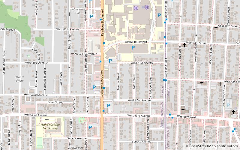
The Hanover Heights Historic District area was developed between 1912 and 1930. It is a 15.5 acres district containing 90 contributing buildings located between State Line Road and Rainbow Boulevard to Olathe Boulevard and West 43rd Avenue in Kansas City, Kansas. It was placed on Register of Historic Kansas Places on December 2, 1989. It was placed on National Register of Historic Places on May 17, 1990. ()
Coordinates: 39°3'9"N, 94°36'38"W
Address
West Kansas City (Rosedale)Kansas City
ContactAdd
Social media
Add
Getting there by public transportation
Public transportation stops near this location
- Bus
 Bus
Bus
- Calculate routeRainbow at 41st 4 min walk
- Calculate routeState Line at 41st 6 min walk
Day trips


Frequently Asked Questions (FAQ)
Which popular attractions are close to Hanover Heights Neighborhood Historic District?
Nearby attractions include H.W. Gates Funeral Home, Kansas City (6 min walk), A.R. Dykes Library, Kansas City (10 min walk), West Plaza, Kansas City (18 min walk), Loretto Academy, Kansas City (19 min walk).
How to get to Hanover Heights Neighborhood Historic District by public transport?
The nearest stations to Hanover Heights Neighborhood Historic District:
Bus
Bus
- Rainbow at 41st • Lines: 11 (4 min walk)
- State Line at 41st • Lines: 11 (6 min walk)