Maling Road, Melbourne


Facts and practical information
Nestled in the heart of Melbourne's leafy eastern suburbs, Maling Road is a charming and vibrant shopping district that offers a unique blend of historical ambiance and contemporary flair. Known for its distinctive Victorian architecture, this quaint street in Canterbury is lined with more than a hundred boutiques, cafes, and specialty shops, making it a favored destination for both locals and tourists seeking a more personalized shopping experience.
Maling Road is not just a shopping destination; it's a step back in time. The heritage-listed precinct boasts beautifully preserved buildings that date back to the early 20th century, offering a picturesque backdrop for a leisurely day out. Visitors can stroll along the cobblestone pathways, admiring the colorful shopfronts that house an eclectic mix of retailers. From high-end fashion boutiques and artisan bakeries to antique stores and home decor shops, Maling Road presents a diverse array of offerings.
One of the district's standout features is its thriving café culture. The area is dotted with intimate eateries and patisseries, where patrons can indulge in a coffee, savor gourmet treats, or enjoy a leisurely brunch. The alfresco dining options add to the European vibe of the precinct, with outdoor seating available for those who wish to people-watch and soak in the atmosphere.
Maling Road also hosts a number of events throughout the year, including the famous Maling Road Auto Classico, an exhibition of classic cars that draws enthusiasts from all over. Seasonal festivities, such as Christmas celebrations, further enhance the community spirit and attract visitors looking for a unique and festive shopping experience.
For those with an appreciation for the arts, the district is home to several galleries showcasing local talent. Art enthusiasts can explore exhibitions of fine art, photography, and handcrafted jewelry, often meeting the artists in person.
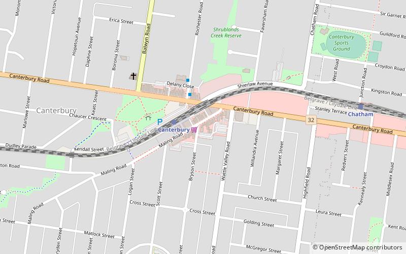
Accessibility is straightforward, with Maling Road situated just a short distance from Canterbury train station. Parking is also available for those who prefer to drive, making it easy for visitors to come and discover all that this historic shopping district has to offer.
145 Maling RdBoroondara (Canterbury)Melbourne 3126
- Bus
- Tram
- Train
 Bus
Bus
- Calculate routeCanterbury 2 min walk
- Calculate routeChatham 10 min walk
- Calculate routeEast Camberwell 20 min walk
- Calculate routeRiversdale 21 min walk
- Calculate routeStop 49: Glyndon Road 17 min walk
- Calculate routeStop 50: Wattle Valley Road 17 min walk
- Calculate routeStop 48: Cooloongatta Road 17 min walk
- Calculate routeStop 51: Highfield Road 18 min walk
- Calculate routeSurrey Hills Railway Station/Windsor Cres 24 min walk
- Calculate routeWebster Street/Riversdale Road 26 min walk
- Calculate routeRiversdale Road 27 min walk
 Melbourne TramsMaps
 Victoria Trains


Frequently Asked Questions (FAQ)
When is Maling Road open?
- Monday 10 am - 5 pm
- Tuesday 10 am - 5 pm
- Wednesday 10 am - 5 pm
- Thursday 10 am - 5 pm
- Friday 10 am - 5 pm
- Saturday 10 am - 5 pm
- Sunday closed
Which popular attractions are close to Maling Road?
How to get to Maling Road by public transport?
Train
- Canterbury (2 min walk)
- Chatham (10 min walk)
Tram
- Stop 49: Glyndon Road • Lines: 70, 70d (17 min walk)
- Stop 50: Wattle Valley Road • Lines: 70, 70d (17 min walk)
Bus
- Surrey Hills Railway Station/Windsor Cres • Lines: 766 (24 min walk)
- Webster Street/Riversdale Road • Lines: 766 (26 min walk)