Redfern Town Hall, Sydney

Gallery (2)
Map
Map
Gallery
Facts and practical information
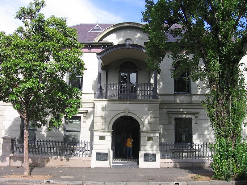
The Redfern Town Hall is a landmark sandstone civic building located in the heart of Redfern, New South Wales, Australia. built in 1870 and designed in the Victorian Regency style by George Allen Mansfield. It was the seat of the Municipality of Redfern from 1870 to 1948. It stands at 73 Pitt Street, Redfern. ()
Coordinates: 33°53'32"S, 151°12'15"E
Address
South Sydney (Redfern)Sydney
ContactAdd
Social media
Add
Getting there by public transportation
Public transportation stops near this location
- Bus
- Light rail
- Train
 Bus
Bus
- Calculate routeRedfern 9 min walk
- Calculate routeCentral 15 min walk
- Calculate routeGreen Square 25 min walk
- Calculate routeMacdonaldtown 29 min walk
- Calculate routeSurry Hills, Cleveland Street nr Crown Street 13 min walk
- Calculate routeStand N, Central Station, Railway Square 15 min walk
- Calculate routeUniversity of Technology Sydney, Broadway 15 min walk
- Calculate routeStand M, Central Station, Railway Square 16 min walk
- Calculate routeSurry Hills 14 min walk
- Calculate routeCentral Chalmers Street 16 min walk
- Calculate routeCentral 18 min walk
- Calculate routeHaymarket 20 min walk
Maps Sydney TrainsMaps
 Sydney Light RailMaps
 Sydney Ferries
Sydney TrainsMapsSydney Light RailMapsSydney FerriesDay trips


Frequently Asked Questions (FAQ)
Which popular attractions are close to Redfern Town Hall?
Nearby attractions include Redfern Park, Sydney (5 min walk), St Andrew's Greek Orthodox Theological College, Sydney (7 min walk), Cathedral of the Annunciation of Our Lady, Sydney (7 min walk), Strawberry Hills, Sydney (9 min walk).
How to get to Redfern Town Hall by public transport?
The nearest stations to Redfern Town Hall:
Train
Bus
Light rail
Train
- Redfern (9 min walk)
- Central (15 min walk)
Bus
- Surry Hills, Cleveland Street nr Crown Street • Lines: 301 (13 min walk)
- Stand N, Central Station, Railway Square • Lines: 607X (15 min walk)
Light rail
- Surry Hills • Lines: L2, L3 (14 min walk)
- Central Chalmers Street • Lines: L2, L3 (16 min walk)