Our Saviour's Cemetery, Copenhagen

Gallery (1)
Map
Map
Facts and practical information
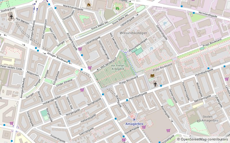
Our Saviour's Cemetery is located at the corner of Amagerbrogade and Prags Boulevard in Copenhagen, Denmark. ()
Address
Amager Øst (Uplands)Copenhagen
ContactAdd
Social media
Add
Getting there by public transportation
Public transportation stops near this location
- Metro
- Bus
- Ferry
 Metro
Metro
- Calculate routeSønderport 4 min walk
- Calculate routeAmagerbro St. 4 min walk
- Calculate routeAmagerfælled Skole 9 min walk
- Calculate routeAmagerbro 4 min walk
- Calculate routeChristianshavn 16 min walk
- Calculate routeLergravsparken 17 min walk
- Calculate routeIslands Brygge 17 min walk
- Calculate routeKnippelsbro 22 min walk
- Calculate routeDet Kongelige Bibliotek 24 min walk
- Calculate routeNyhavn 26 min walk
- Calculate routeOperaen 29 min walk
Maps Metro
Metro
MetroDay trips
Our Saviour's Cemetery – popular in the area (distance from the attraction)
Nearby attractions include: Church of Our Saviour, Amager Centret, DR Koncerthuset, Black Diamond.


Frequently Asked Questions (FAQ)
Which popular attractions are close to Our Saviour's Cemetery?
Nearby attractions include Kvarterhuset, Copenhagen (3 min walk), Nathanael's Church, Copenhagen (4 min walk), Holmbladsgade, Copenhagen (5 min walk), Vermlandsgade, Copenhagen (7 min walk).
How to get to Our Saviour's Cemetery by public transport?
The nearest stations to Our Saviour's Cemetery:
Bus
Metro
Ferry
Bus
- Sønderport • Lines: 5C (4 min walk)
- Amagerbro St. • Lines: 250S, 5C (4 min walk)
Metro
- Amagerbro • Lines: M2 (4 min walk)
- Christianshavn • Lines: M1, M2 (16 min walk)
Ferry
- Knippelsbro • Lines: 991, 992 (22 min walk)
- Det Kongelige Bibliotek • Lines: 991, 992 (24 min walk)