Piz Grialetsch
#1043 among destinations in Switzerland


Facts and practical information
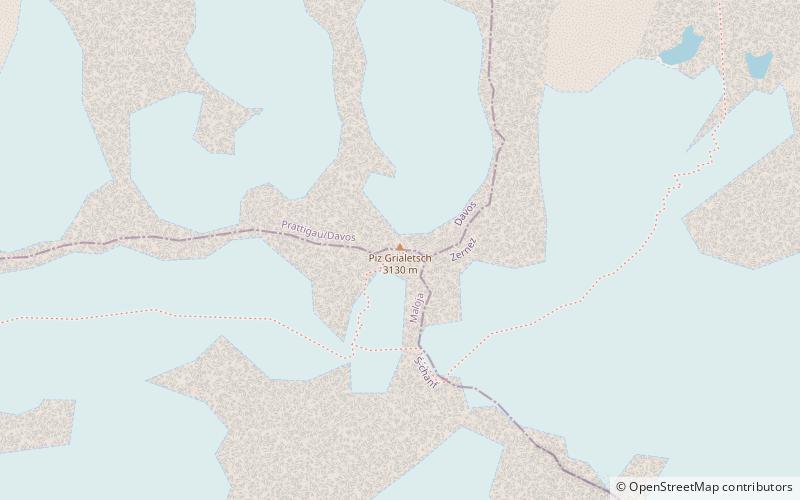
Piz Grialetsch is a mountain of the Albula Alps, Switzerland, overlooking the Fuorcla da Grialetsch in the canton of Graubünden. It lies on the range between the Dischma and Engadin valleys, which culminates at Piz Vadret. ()
Piz Grialetsch plan & book
Unleash the traveler in you — discover the cheapest flight deals, find the perfect hotel or hostel nearby, and search for the best car rental prices. Travel at your own pace to discover new places and enjoy your journey.
Piz Grialetsch – popular in the area (distance from the attraction)
Nearby attractions include: Jakobshorn, Schwarzhorn, Piz Kesch, Flüela Wisshorn.
7.4 miNW
Nature, Natural attraction, Ski areaJakobshorn, Davos
189 min walk • The Jakobshorn is a mountain of the Albula Alps, overlooking Davos in the Swiss canton of Graubünden. It is also one of the five skiing regions of the Davos Klosters Mountains, offering 14 pistes.
3 miN
Nature, Natural attraction, MountainSchwarzhorn
76 min walk • The Flüela Schwarzhorn is a mountain of the Albula Alps, overlooking the Flüela Pass, in the canton of Graubünden. With a height of 3,146 metres above sea level, it is the highest point of the Albula Alps north of the Fuorcla da Grialetsch.
6.3 miSW
Alpine mountain with hiking trailsPiz Kesch
162 min walk • Piz Kesch or Piz d'Es-cha is a peak in the Albula Alps of the Rhaetian Alps in Switzerland. At 3,418 metres, it is the highest peak in the Albula Alps and the municipality of Bergün, Grisons. The first ascent was made 1846 by J. Coaz, J. Rascher, C. Casper and J. Tscharner.
4.8 miN
Nature, Natural attraction, MountainFlüela Wisshorn
122 min walk • The Flüela Wisshorn is a mountain of the Silvretta Alps, overlooking the Flüela Pass in the Swiss canton of Graubünden.
5.8 miSW
Natural featurePorchabella Glacier, Zuoz
149 min walk • The Porchabella Glacier is a 2.5 km long glacier situated in the Albula Range in the canton of Graubünden in Switzerland. In 1973 it had an area of 2.58 km². The glacier lies at the foot of Piz Kesch and Piz Val Müra. It gives birth to the river Ava da Salect which ends in the Albula.
6.8 miSW
Natural featureAlbula Alps, Zuoz
173 min walk • The Albula Alps are a mountain range in the Alps of eastern Switzerland. They are considered to be part of the Central Eastern Alps, more specifically the Western Rhaetian Alps. They are named after the river Albula.
5.5 miNW
Nature, Natural attraction, ValleySertig
141 min walk • The Sertig Valley is located in the municipality of Davos, south of the town, in the Swiss canton of Graubünden. It is a lateral valley of the Landwasser valley. The small village of Sertig Dörfli is accessible by road.
4.2 miW
Nature, Natural attraction, LakeLai da Ravais-ch
108 min walk • The Lai da Ravais-ch is an Alpine lake located south of the Sertig Pass and west of the Sella da Ravais-ch, in the Swiss canton of Graubünden. The lake has an area of 0.093 km² and is located at 2,505 metres above sea level. It is located in the municipality of Bergün.
4 miN
High mountain pass closed in winterFlüela Pass, Davos
102 min walk • The Flüela Pass is a high mountain pass of the Swiss Alps in Graubünden. Traditionally considered the boundary between the Albula and Silvretta Alps, the pass crosses the watershed / drainage divide between the basins of the Rivers Rhine and Danube. The pass is overlooked by the Flüela Schwarzhorn and the Flüela Wisshorn.
0.6 miSE
Nature, Natural attraction, MountainPiz Vadret
16 min walk • Piz Vadret is a mountain of the Albula Alps, in Graubünden. With an altitude of 3,229 metres above sea level, Piz Vadret is the highest mountain of the Albula Alps north of Piz Kesch.
4.9 miW
Nature, Natural attraction, MountainHoch Ducan
126 min walk • The Hoch Ducan is a mountain in the Albula Range, located in Graubünden, Switzerland.
