Stellihorn
#412 among destinations in Switzerland
Facts and practical information
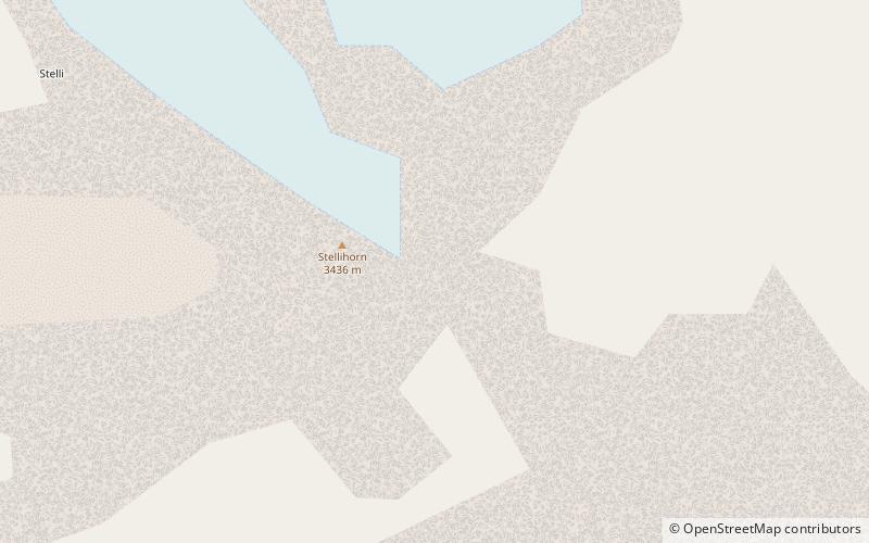
The Stellihorn is a mountain of the Swiss Pennine Alps, overlooking the lake of Mattmark in the canton of Valais. It lies south of Saas-Almagell in the upper valley of Saas. The north side is covered by a glacier named Nollen Gletscher. ()
ValaisSwitzerland
Stellihorn plan & book
Unleash the traveler in you — discover the cheapest flight deals, find the perfect hotel or hostel nearby, and search for the best car rental prices. Travel at your own pace to discover new places and enjoy your journey.
Stellihorn – popular in the area (distance from the attraction)
Nearby attractions include: Britannia Hut, Mattmarksee, Allalinhorn, Monte Moro.
- 3.7 miNWAlpine hut, Hiking
Britannia Hut
94 min walk • Nestled amidst the awe-inspiring peaks of the Swiss Alps, the Britannia Hut stands as a beacon for mountaineers and hikers traversing the vast alpine wilderness. This storied alpine hut, located at an elevation of 3,030 meters, is a popular base for those attempting...
- 2 miWNature, Natural attraction, Lake
Mattmarksee
52 min walk • Nestled amidst the majestic peaks of the Swiss Alps, Mattmarksee is a serene alpine lake that captivates visitors with its tranquil beauty. Located in the Saas Valley of the Canton of Valais, this reservoir plays a dual role as both a natural wonder and an important...
- 5.2 miW4000m Alps peak with a moderate ascent
Allalinhorn
134 min walk • The Allalinhorn is a mountain in the Pennine Alps in Switzerland. It lies between Zermatt and Saas-Fee in the canton of Valais, and is part of the Mischabel range, which culminates at the Dom.
- 2.9 miSWNature, Natural attraction, Mountain
Monte Moro
73 min walk • Monte Moro is a mountain of the Pennine Alps, located on the Swiss-Italian border. It lies west of the Monte Moro Pass.
- 5.1 miWNature, Natural attraction, Mountain
Strahlhorn
130 min walk • The Strahlhorn is a mountain of the Swiss Pennine Alps, located south of Saas-Fee and east of Zermatt in the canton of Valais. It lies on the range that separates the Mattertal from the Saastal and is located approximately halfway between the Rimpfischhorn and the Schwarzberghorn.
- 6.2 miNWNature, Natural attraction, Mountain
Längfluh
159 min walk • The Längfluh is a rocky outcrop of the Pennine Alps, dividing the Fee Glacier above Saas Fee in the canton of Valais. The Längfluh is accessible by cable car and is part of a ski area.
- 4.8 miNNature, Natural attraction, Mountain
Portjengrat
122 min walk • The Portjengrat is a mountain of the Pennine Alps, located on the border between Switzerland and Italy. It lies south of the Weissmies and the Zwischbergen Pass, where the international border diverges away from the main Alpine watershed.
- 7.5 miNWAlpine hut, Hiking
Mischabel Hut
191 min walk • The Mischabel Hut is a mountain hut of the Academic Alpine Club of Zurich, located west of Saas Fee in the canton of Valais. It lies at a height of 3,340 metres above sea level near the Hohbalmgletscher glacier, on the eastern flanks of the Dom and the Lenzspitze in the Mischabel group.
- 0.5 miSENature, Natural attraction, Mountain
Jazzihorn
14 min walk • The Jazzihorn is a mountain of the Pennine Alps, located on the Swiss-Italian border. On the Italian side it is named Pizzo Cingino Nord as another summit is named Pizzo Cingino Sud on the south.
- 6.4 miSWNature, Natural attraction, Mountain
Cima di Jazzi
164 min walk • The Cima di Jazzi is a mountain of the Pennine Alps, located on the Swiss-Italian border, just north of Monte Rosa. It overlooks Macugnaga on its east side. The west side is entirely covered by glaciers.
- 5.3 miNWNature, Natural attraction, Mountain
Felskinn
135 min walk • Felskinn is a rocky outcrop of the Pennine Alps, situated above Saas Fee in the canton of Valais. Felskinn is the lower station of the Metro Alpin which gives access to the Mittelallalin.