Tannensee
#155 among destinations in Switzerland


Facts and practical information
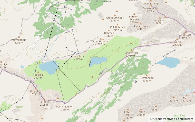
Tannensee is a reservoir in Obwalden, Switzerland. In 1958, Tannenbach and few other creeks were dammed with an earth-fill dam. The reservoir has a volume of 3.8 mio m³ and its surface area is 33 ha. The reservoir is used to generate electricity at Kraftwerk Hugschwendi in Kerns. ()
ObwaldenSwitzerland
Tannensee plan & book
Unleash the traveler in you — discover the cheapest flight deals, find the perfect hotel or hostel nearby, and search for the best car rental prices. Travel at your own pace to discover new places and enjoy your journey.
Tannensee – popular in the area (distance from the attraction)
Nearby attractions include: Trübsee, Engstlensee, Planplatten, Graustock.
4.2 miEHigh-altitude lake in ski regionTrübsee, Engelberg
108 min walk • Trübsee is an intermediate cable car station by the Titlis Bergbahnen, Trüebsee is an Alpine lake on the Ober Trüebsee Alpine pasture in the upper part of the extensive municipality of Wolfenschiessen in the Swiss canton of Nidwalden.
2.4 miENature, Natural attraction, LakeEngstlensee
62 min walk • Nestled in the Bernese Alps of Switzerland, Engstlensee is a serene mountain lake that captivates the hearts of nature enthusiasts and photographers alike. At an elevation of approximately 1,850 meters above sea level, this natural wonder is a hidden gem known for its...
3.5 miSWNature, Natural attraction, MountainPlanplatten
90 min walk • Planplatten is a mountain situated above Meiringen in the Bernese Oberland in Switzerland. In 1999 a panoramic restaurant has been built on the summit which is accessible by gondola lift.
3.1 miENature, Natural attraction, MountainGraustock, Engelberg
79 min walk • The Graustock is a mountain of the Urner Alps, located south of Engelberg in Central Switzerland. The summit is one of the two tripoints between the cantons of Berne, Nidwalden and Obwalden. On the north side of the mountain lies the Trüebsee.
4.2 miENature, Natural attraction, MountainJochstock
108 min walk • The Jochstock is a summit of the Urner Alps, located near Engelberg in Central Switzerland. The summit is one of the two tripoints between the cantons of Berne, Nidwalden and Obwalden.
3.2 miWNature, Natural attraction, MountainHochstollen
82 min walk • The Hochstollen is a mountain of the Urner Alps, located between the Klein Melchtal and the Melchtal in the canton of Obwalden. The border with the canton of Bern runs south of the summit. The closest locality is Melchsee-Frutt on its east side.
1.6 miWNature, Natural attraction, LakeMelchsee
41 min walk • Melchsee is a lake in the canton of Obwalden, Switzerland. It lends its name to the resort Melchsee-Frutt, in the municipality of Kerns. At an elevation of 1891 m, its surface area is 54 ha.
2.6 miNENature, Natural attraction, MountainRotsandnollen
66 min walk • The Rotsandnollen is a mountain of the Urner Alps, located between Melchsee-Frutt and Engelberg in Central Switzerland. The summit is located on the border between the cantons of Nidwalden and Obwalden.
2.7 miWNature, Natural attraction, MountainHaupt Mountain
69 min walk • The Haupt is a mountain of the Urner Alps, located between the Klein Melchtal and the Melchtal in the canton of Obwalden. Its east side consists of steep limestone cliffs overlooking Stöckalp and Melchsee-Frutt. On its west side it overlooks the Älggi-Alp.
2.6 miSWNature, Natural attraction, MountainGlogghüs
66 min walk • The Glogghüs is a mountain of the Urner Alps, located on the border between the Swiss cantons of Obwalden and Bern. On its northern side it overlooks the Melchsee and the village of Melchsee-Frutt.
3.6 miNNature, Natural attraction, MountainNünalphorn
91 min walk • The Nünalphorn is a mountain of the Urner Alps, located on the border between the Swiss cantons of Nidwalden and Obwalden. It is located between the valleys of Melchtal and Engelberg.