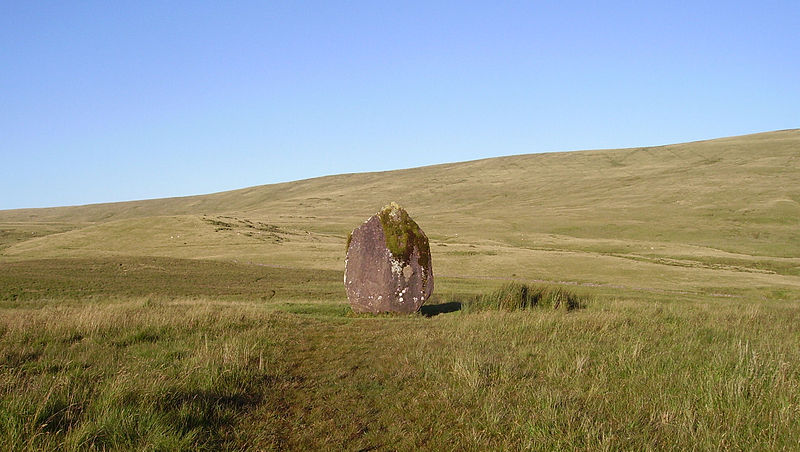
Maen Llia, Brecon
#5 among attractions in Brecon

Facts and practical information
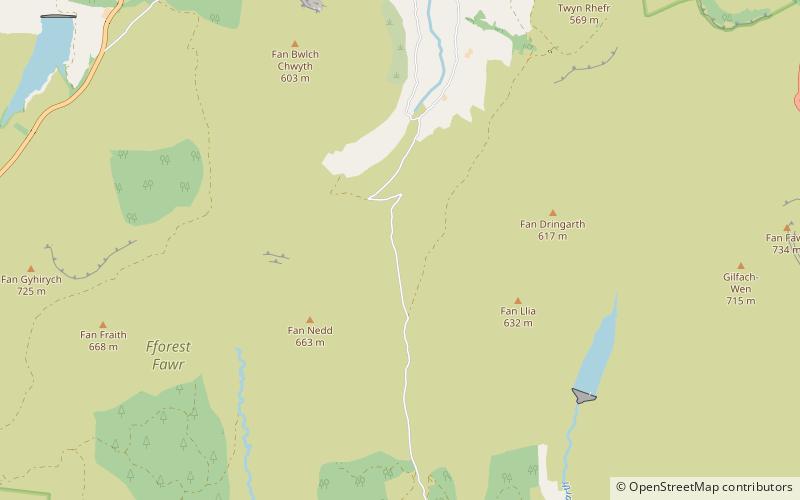
Maen Llia is a standing stone which sits on moorland at grid reference SN924192 in the Brecon Beacons National Park in Powys, Wales. ()
Brecon United Kingdom
Brecon plan & book
Unleash the traveler in you — discover the cheapest flight deals, find the perfect hotel or hostel nearby, and search for the best car rental prices. Travel at your own pace to discover new places and enjoy your journey.
Maen Llia – popular in the area (distance from the attraction)
Nearby attractions include: Fan Gyhirych, Maen Madoc, Fan Fawr, Fan Llia.
 Nature, Natural attraction, Mountain
Fan Gyhirych, Brecon Beacons
69 min walk • Fan Gyhirych is a mountain in the Fforest Fawr section of Brecon Beacons National Park in south Wales. It lies within the county of Breconshire, and administered as part of the unitary authority of Powys.
 Memorial
Maen Madoc, Brecon Beacons
55 min walk • The Maen Madoc or Maen Madog stone is a menhir which lies adjacent to the Roman road Sarn Helen that runs across the Brecon Beacons in what was a key area of Roman Wales, about one mile north of Ystradfellte. It stands approximately 10 feet high.
 Nature, Natural attraction, Mountain
Fan Fawr, Brecon Beacons
73 min walk • Fan Fawr is a mountain in the Fforest Fawr section of the Brecon Beacons National Park, in Powys, Wales and over 734 m high. The summit overlooks the steep eastern face and is marked by a cairn.
 Nature, Natural attraction, Mountain
Fan Llia, Brecon Beacons
24 min walk • Fan Llia is a subsidiary summit of Fan Fawr in the Fforest Fawr section of the Brecon Beacons National Park, Wales. In common with other peaks in the Fforest Fawr uplands it lies within the county of Powys.
 Nature, Natural attraction, Mountain
Fan Nedd, Brecon Beacons
22 min walk • Fan Nedd is a mountain in the Fforest Fawr area of the Brecon Beacons National Park in Wales. In common with the rest of the Fforest Fawr uplands it is within the county of Powys.
 Nature, Natural attraction, Mountain
Fan Fraith, Brecon Beacons
58 min walk • Fan Fraith is a top of Fan Gyhirych in the Fforest Fawr section of the Brecon Beacons National Park in the county of Powys, south Wales. Its summit is at a height of 2192 feet or 668 m. It lies within Fforest Fawr Geopark.
 Nature, Natural attraction, Mountain
Fan Bwlch Chwyth, Brecon Beacons
44 min walk • Fan Bwlch Chwyth is a peak in the Fforest Fawr section of the Brecon Beacons National Park and within the county of Powys. Its summit is marked by a trig point at OS grid ref SN 912217.
 Dam
DamYstradfellte Reservoir, Brecon Beacons
44 min walk • Ystradfellte Reservoir is a water storage reservoir on the Afon Dringarth in the upland area of Fforest Fawr within the Brecon Beacons National Park in South Wales.
 Nature, Natural attraction, Mountain
Craig Cerrig-gleisiad and Fan Frynych National Nature Reserve, Brecon Beacons
68 min walk • Craig Cerrig-gleisiad and Fan Frynych National Nature Reserve is a 156 acre area of the Brecon Beacons National Park in South Wales. It includes the peaks of Craig Cerrig-gleisiad and Fan Frynych.
 Nature, Natural attraction, Natural feature
Fforest Fawr, Brecon Beacons
29 min walk • Fforest Fawr is an extensive upland area in the county of Powys, Wales. Formerly known as the Great Forest of Brecknock in English, it was a royal hunting area for several centuries but is now used primarily for sheep grazing, forestry, water catchment and recreation.
 Nature, Natural attraction, Mountain
Carreg Cadno, Pen y Cae
93 min walk • Carreg Cadno is a hill five miles northeast of Abercraf in the county of Powys, south Wales. It lies within the Brecon Beacons National Park and Fforest Fawr Geopark. Its summit at OS grid ref SN 874161 reaches a height of 538m / 1763 ft above sea level.


