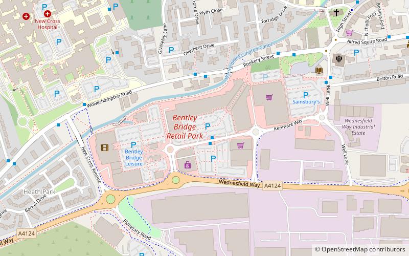
Bentley Bridge Retail Park, Wolverhampton
Map
Facts and practical information
Bentley Bridge Leisure Park is an extensive modern leisure/retail park located in the Wednesfield area of Wolverhampton in the West Midlands. It has been developed since the late 1990s, to the south of Wednesfield town centre. ()
Stores: 23Coordinates: 52°35'48"N, 2°5'20"W
Getting there by public transportation
Public transportation stops near this location
- Bus
- Tram
 Bus
Bus
- Calculate routeBentley Bridge Way / Bentley Bridge Retail Park 1 min walk
- Calculate routeWolverhampton Road / Graisley Lane 3 min walk
- Calculate routeRookery St / Hall St 5 min walk
- Calculate routeN4 6 min walk
- Calculate routeThe Royal 41 min walk
Day trips
Bentley Bridge Retail Park – popular in the area (distance from the attraction)
Nearby attractions include: Holy Trinity Church, Wednesfield, Horseley Fields Junction, St Thomas' Church.


Frequently Asked Questions (FAQ)
Which popular attractions are close to Bentley Bridge Retail Park?
Nearby attractions include St Thomas' Church, Wolverhampton (8 min walk), Wednesfield, Wolverhampton (9 min walk), Holy Trinity Church, Wolverhampton (15 min walk).
How to get to Bentley Bridge Retail Park by public transport?
The nearest stations to Bentley Bridge Retail Park:
Bus
Tram
Bus
- Bentley Bridge Way / Bentley Bridge Retail Park • Lines: 53, 60, 65 (1 min walk)
- Wolverhampton Road / Graisley Lane • Lines: 59, 71 (3 min walk)
Tram
- The Royal • Lines: 1 (41 min walk)