Mount Morgan, John Muir Wilderness
#16 among attractions in John Muir Wilderness
![Mount Morgan location map](https://tzmedia.b-cdn.net/media/images/static-maps/us/37_4055_-118_734.jpg)
Facts and practical information
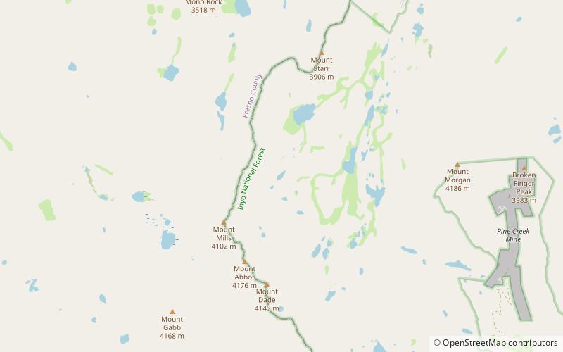
Mount Morgan is a mountain located in northwestern Inyo County, California, in the John Muir Wilderness of the Inyo National Forest. ()
John Muir Wilderness United States
John Muir Wilderness plan & book
Unleash the traveler in you — discover the cheapest flight deals, find the perfect hotel or hostel nearby, and search for the best car rental prices. Travel at your own pace to discover new places and enjoy your journey.
Mount Morgan – popular in the area (distance from the attraction)
Nearby attractions include: Mount Tom, Mount Abbot, Mount Mills, Mills Lake.
6.2 miSENature, Natural attraction, MountainMount Tom, John Muir Wilderness
159 min walk • Mount Tom is a large and prominent peak near the city of Bishop in Inyo County of eastern California. It is in the Sierra Nevada and east of the Sierra Crest. The mountain is also in the John Muir Wilderness.
3.1 miSWNature, Natural attraction, MountainMount Abbot, John Muir Wilderness
79 min walk • Mount Abbot is a mountain in California's Sierra Nevada, in the John Muir Wilderness. It is located between Mount Mills and Mount Dade along the Sierra Crest and straddles the border between Fresno and Inyo counties.
3.2 miWNature, Natural attraction, MountainMount Mills, John Muir Wilderness
83 min walk • Mount Mills is a Thirteener and California 4000 meter peak, on the Sierra Crest, north of Mount Abbot and south of Mono Pass in the Sierra Nevada. The mountain is located within the John Muir Wilderness area. The 13,457 feet summit marks the boundary between northwestern Inyo County and eastern Fresno County.
2.3 miWNature, Natural attraction, LakeMills Lake, John Muir Wilderness
59 min walk • Mills Lake is a California waterbody along the Sierra Crest east of Ruby Peak and Mount Mills near Little Lakes Valley. The discharge of Mills Lake flows through Ruby Lake, Rock Creek Lake, and into Rock Creek.
3.2 miSWNature, Natural attraction, MountainBear Creek Spire, John Muir Wilderness
82 min walk • Bear Creek Spire is a mountain in the Sierra Nevada in Inyo County, California, in the western United States, and is the 46th highest mountain in California and the 225th highest mountain in the United States. Bear Creek Spire is part of the John Muir Wilderness and the Inyo National Forest.
5.9 miNWNature, Natural attraction, MountainMount Hopkins, John Muir Wilderness
151 min walk • Mount Hopkins is a mountain in the John Muir Wilderness north of Kings Canyon National Park. It is one of four peaks that surround Pioneer Basin, 1.4 miles south-southeast of Mount Crocker, 2 miles west-southwest of Mount Huntington, and 2 miles southwest of Mount Stanford.
4.3 miSWNature, Natural attraction, MountainMount Gabb, John Muir Wilderness
110 min walk • Mount Gabb is in the central Sierra Nevada in the U.S. state of California. Mount Gabb is in the John Muir Wilderness of Sierra National Forest and is named after William More Gabb, a paleontologist and member of the Whitney Survey.
2.6 miWNature, Natural attraction, MountainRuby Peak, John Muir Wilderness
68 min walk • Ruby Peak is a thirteener on the Sierra Crest, north of Mount Mills. It is in the John Muir Wilderness and on the boundary between the Sierra National Forest and the Inyo National Forest. It is near Mono Pass.
4.6 miSWMountain pass, NatureItaly Pass, Devils Postpile National Monument
117 min walk • Italy Pass, is a gap at an elevation of 12,408 feet, in the Sierra Nevada Mountains in Inyo County, California.