Starburst Intersection, Washington D.C.
Map
Facts and practical information
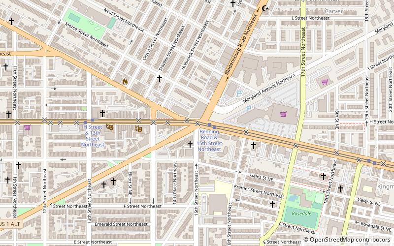
The Starburst Intersection refers to the intersection of six streets in northeast Washington, D.C.: Bladensburg Road NE (part of U.S. Route 1 Alternate, Benning Road NE, 15th Street NE, Maryland Avenue NE, and H Street NE intersect directly, and to the immediate northwest of this intersection is the easternmost point of Florida Avenue. The name "starburst" refers to the star-like shape created by these roads when viewed on a map. ()
Coordinates: 38°54'1"N, 76°59'1"W
Address
Northeast Washington (Trinidad - Langston)Washington D.C.
ContactAdd
Social media
Add
Getting there by public transportation
Public transportation stops near this location
- Metro
- Tram
- Train
 Metro
Metro
- Calculate routeBenning Road & 15th Street Northeast 1 min walk
- Calculate routeH Street & 8th Street Northeast 16 min walk
- Calculate routeStadium–Armory 26 min walk
- Calculate routeNoMa–Gallaudet U 30 min walk
- Calculate routeHart 31 min walk
Day trips


Frequently Asked Questions (FAQ)
Which popular attractions are close to Starburst Intersection?
Nearby attractions include Atlas Performing Arts Center, Washington D.C. (6 min walk), Atlas District, Washington D.C. (6 min walk), Rosedale Recreation Center, Washington D.C. (8 min walk), Roosevelt Apartment Building, Washington D.C. (11 min walk).
How to get to Starburst Intersection by public transport?
The nearest stations to Starburst Intersection:
Tram
Metro
Train
Tram
- Benning Road & 15th Street Northeast • Lines: H Street/Benning Road Streetcar (1 min walk)
- H Street & 8th Street Northeast • Lines: H Street/Benning Road Streetcar (16 min walk)
Metro
- Stadium–Armory • Lines: Bl, Or, Sv (26 min walk)
- NoMa–Gallaudet U • Lines: Rd (30 min walk)
Train
- Hart (31 min walk)