Upper South Providence, Providence
Map
Facts and practical information
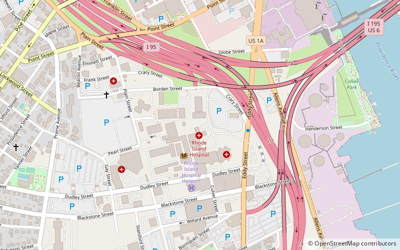
Upper South Providence is an official neighborhood in the South Side in the city of Providence, Rhode Island. It is bound to the north by Interstate 95, the east by the Providence River, to the south by Public Street, and the west by Broad Street. Often associated with Lower South Providence directly to its south, Upper South Providence is a distinct neighborhood. ()
Coordinates: 41°48'44"N, 71°24'33"W
Address
Upper South ProvidenceProvidence
ContactAdd
Social media
Add
Getting there by public transportation
Public transportation stops near this location
- Bus
- Train
 Bus
Bus
- Calculate routeEddy and Borden 3 min walk
- Calculate routeDorrance and Pine 19 min walk
- Calculate routeKennedy Plaza Intermodal Transportation Center 23 min walk
- Calculate routeKennedy Plaza Stop V 24 min walk
- Calculate routeProvidence 31 min walk
Day trips


Frequently Asked Questions (FAQ)
Which popular attractions are close to Upper South Providence?
Nearby attractions include Rhodes Street Historic District, Providence (8 min walk), Davol Rubber Company, Providence (10 min walk), Providence Jewelry Manufacturing Historic District, Providence (10 min walk), Jewelry District, Providence (11 min walk).
How to get to Upper South Providence by public transport?
The nearest stations to Upper South Providence:
Bus
Train
Bus
- Eddy and Borden • Lines: 3, 3A, 3B (3 min walk)
- Dorrance and Pine • Lines: 1, 3, 3A, 3B, 62 (19 min walk)
Train
- Providence (31 min walk)