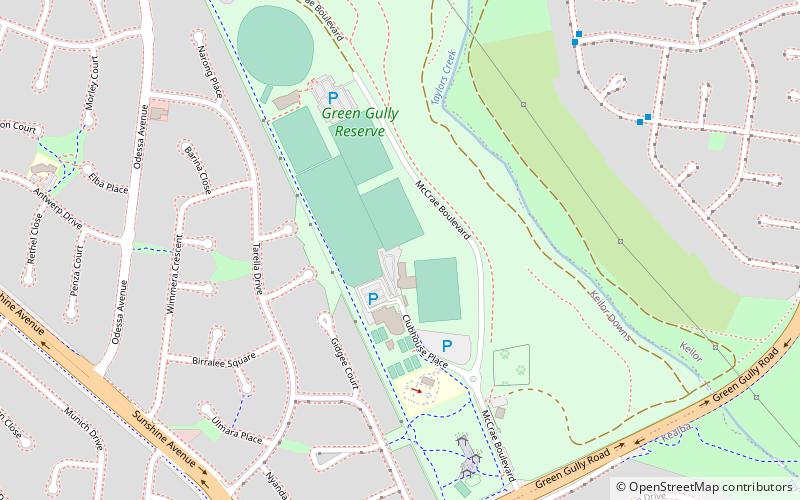
Green Gully Reserve, Melbourne

Gallery (1)
Map
Map
Facts and practical information
Green Gully Reserve is the home of Victorian Premier League team Green Gully. It is based in Melbourne, Victoria. Green Gully Reserve has a capacity of 10,000. The reserve has 7 soccer grounds in total. Three of them used for match days and the other three for training purposes. There is one ground right next to the Green Gully training pitches, but it does not belong to Green Gully, it belongs to the Keilor Wolves Soccer Club. The ground has quality lighting used for night matches and an undercover standing room. ()
Opened: 1966 (60 years ago)Capacity: 10 thous.Coordinates: 37°43'25"S, 144°49'5"E
Address
Brimbank (Keilor Downs)Melbourne
ContactAdd
Social media
Add
Getting there by public transportation
Public transportation stops near this location
- Bus
 Bus
Bus
- Calculate routeLoddon Avenue/Patterson Avenue 9 min walk
- Calculate routeCampaspe Crescent/Patterson Avenue 9 min walk
- Calculate routeBarwon Avenue/Patterson Avenue 14 min walk
- Calculate routeTambo Court/Green Gully Road 15 min walk
Maps Melbourne TramsMaps
 Victoria Trains
Melbourne TramsMapsVictoria TrainsDay trips


Frequently Asked Questions (FAQ)
How to get to Green Gully Reserve by public transport?
The nearest stations to Green Gully Reserve:
Bus
Bus
- Loddon Avenue/Patterson Avenue • Lines: 476 (9 min walk)
- Campaspe Crescent/Patterson Avenue • Lines: 476 (9 min walk)