Flimspitz
#683 among destinations in Austria
![Flimspitz location map](https://tzmedia.b-cdn.net/media/images/static-maps/at/46_9847_10_3454.jpg)
Facts and practical information
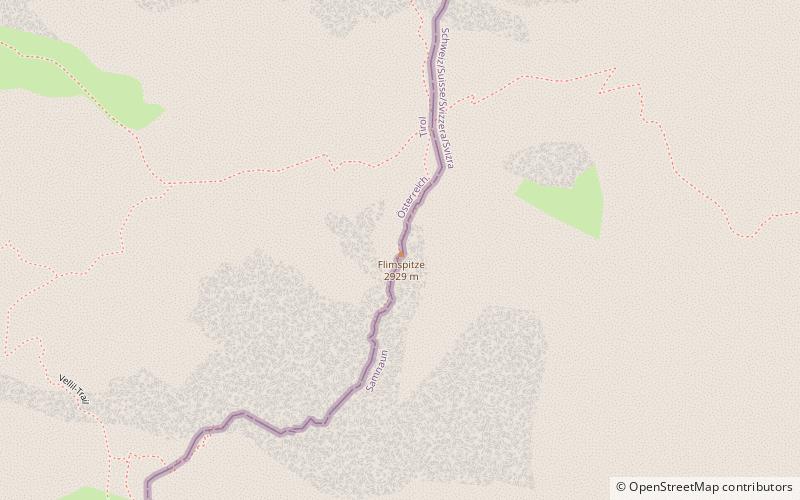
Flimspitz is a mountain of the Samnaun Alps, located on the border between Switzerland and Austria. It lies on the range between the Greitspitz and the Bürkelkopf. ()
TyrolAustria
Flimspitz – popular in the area (distance from the attraction)
Nearby attractions include: Greitspitz, Bürkelkopf, Palinkopf, Vesulspitze.
1.1 miSWNature, Natural attraction, MountainGreitspitz
30 min walk • The Greitspitz is a mountain of the Samnaun Alps, located on the border between Switzerland and Austria. It lies approximately halfway between Samnaun and Ischgl. In winter it is part of the ski area Silvretta Arena.
~1830 ftNNature, Natural attraction, MountainBürkelkopf
9 min walk • Bürkelkopf is a mountain of the Samnaun Alps, located on the border between Austria and Switzerland. It lies between Ischgl and Samnaun. In winter it is part of a ski area.
2.9 miSWNature, Natural attraction, MountainPalinkopf
75 min walk • The Palinkopf is a mountain of the Samnaun Alps, located on the border between Switzerland and Austria. It lies west of Samnaun and is part of the Samnaun-Ischgl ski area.
1.2 miNNature, Natural attraction, MountainVesulspitze
31 min walk • The Vesulspitze is a mountain of the Samnaun Alps, located near Ischgl in Austria. With an elevation of 3,089 metres above sea level, it is the highest summit of the Samnaun Alps north of the Zeblasjoch.
7 miNWNature, Natural attraction, MountainKuchenspitze
179 min walk • The Kuchenspitze is a mountain, 3,148 m, in the Verwall between the valley of Stanzer Tal and Paznaun in the west of North Tyrol.
3.2 miNWTownIschgl
81 min walk • In addition to its world-class skiing, Ischgl is also known for its vibrant apres-ski scene, with numerous bars and restaurants offering a lively atmosphere and delicious Austrian cuisine. After a day on the slopes, visitors can unwind with a glass of gluhwein...
5.8 miNWNature, Natural attraction, MountainSaumspitze
148 min walk • The Saumspitze is a 3,039 m mountain in the Verwall Alps, a mountain range of the Central Eastern Alps. It is situated in the West of the Austrian state of Tyrol.
6.6 miNWNature, Natural attraction, MountainKüchlspitze
168 min walk • The Küchlspitze is a three-thousander in the Verwall between the valley of Stanzer Tal and Paznaun in the western North Tyrol in Austria.
3.3 miSWNature, Natural attraction, ValleyFimbatal
83 min walk • The Fimbatal, also Fimbertal, is an alpine valley situated between the Silvretta Alps and the Samnaun Alps. The valley is drained by the Fimbabach river, a tributary of the Inn basin at Ischgl. The highest mountain bordering the Fimbatal is the Fluchthorn.
5.5 miNLocalityKappl
141 min walk • Kappl is a municipality in the district of Landeck in the Austrian state of Tyrol located about 17 km southwest of Landeck in the Paznaun Valley. It is one of the larger municipalities in the valley. Kappl was mentioned for the first time in 1370. The main source of income is tourism.
5.5 miNAlpine hut, HikingNiederelbehütte
142 min walk • Niederelbehütte is a refuge of the Hamburg and Niederelbe section of the German Alpine Club. It is located in the Austrian province of Tyrol in the Verwallgruppe at an altitude of 2310 m above sea level and is managed from July to September.