Sankt-Marien-Kirche, Bad Homburg

Gallery (2)
Map
Map
Gallery
Facts and practical information
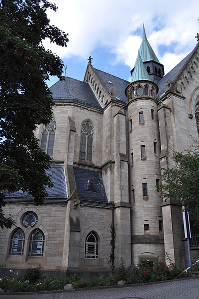
The Marienkirche or St. Mary's is the main Roman Catholic church in Bad Homburg vor der Höhe. Like many other houses in Dorotheenstraße, it is a listed building. It is the parish church of the pastoral area Bad Homburg-Friedrichsdorf in the church district Hochtaunus.
Coordinates: 50°13'34"N, 8°36'49"E
Getting there by public transportation
Public transportation stops near this location
- Metro
- Bus
- Train
 Metro
Metro
- Calculate routeKurhaus 4 min walk
- Calculate routeSchleußnerstraße 6 min walk
- Calculate routeMarkt 6 min walk
- Calculate routeBad Homburg 13 min walk
- Calculate routeGonzenheim 33 min walk
Day trips


Frequently Asked Questions (FAQ)
Which popular attractions are close to Sankt-Marien-Kirche?
Nearby attractions include Galerie, Bad Homburg (2 min walk), Church of the Redeemer, Bad Homburg (3 min walk), Kriegerdenkmal 1870/71, Bad Homburg (3 min walk), Museum Sinclair Haus, Bad Homburg (3 min walk).
How to get to Sankt-Marien-Kirche by public transport?
The nearest stations to Sankt-Marien-Kirche:
Bus
Train
Metro
Bus
- Kurhaus • Lines: 1, 11, 12, 17, 2, 21, 22, 23, 261, 3, 31, 32, 33, 4, 5, 50, 51, 54, 57, 6, 7, X26 (4 min walk)
- Schleußnerstraße • Lines: 1, 11, 12, 2, 21, 22, 23, 3, 31, 32, 33, 34, 4, 5, 6 (6 min walk)
Train
- Bad Homburg (13 min walk)
Metro
- Gonzenheim • Lines: U2 (33 min walk)