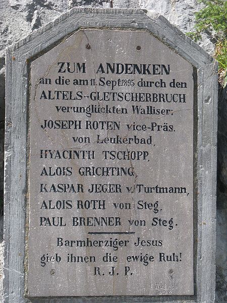
Altels
#525 among destinations in Switzerland


Facts and practical information
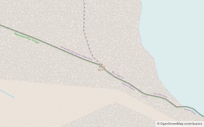
The Altels is a mountain of the Bernese Alps, located on the border between the Swiss cantons of Bern and Valais. It is situated in the Balmhorn massif, approximately halfway between Kandersteg and Leukerbad. ()
ValaisSwitzerland
Altels plan & book
Unleash the traveler in you — discover the cheapest flight deals, find the perfect hotel or hostel nearby, and search for the best car rental prices. Travel at your own pace to discover new places and enjoy your journey.
Altels – popular in the area (distance from the attraction)
Nearby attractions include: Daubensee, Balmhorn, Daubenhorn, Torrenthorn.
3.1 miSWNature, Natural attraction, LakeDaubensee
79 min walk • Nestled in the heart of the Swiss Alps, Daubensee, also known as Lake Dauben, is a serene mountain lake that offers a tranquil escape from the bustle of urban life. Situated at an elevation of approximately 2207 meters above sea level, this alpine gem is a popular...
0.8 miEForested mountain with alpine hutsBalmhorn
20 min walk • The Balmhorn is a mountain in the Bernese Alps in Switzerland. Its summit ridge lies on the border between the cantons of Berne and the Valais.
4.6 miSWAlpine summit and via ferrataDaubenhorn
117 min walk • The Daubenhorn is a mountain in the Bernese Alps, located above the town of Leukerbad, Switzerland. The mountain has the longest via ferrata, or secured climbing route, in Switzerland.
3.6 miSNature, Natural attraction, MountainTorrenthorn
91 min walk • The Torrenthorn is a mountain of the Bernese Alps, overlooking Leukerbad in the canton of Valais. It lies south of the Majinghorn. In winter the Torrenthorn is part of a ski area.
3.5 miEPeak with skiing and mountaineeringHockenhorn
91 min walk • The Hockenhorn is a mountain of the Bernese Alps, located on the border between the Swiss cantons of Bern and Valais. Its summit is 3,293 metres high and lies between the upper Kandertal and the Lötschental.
4.2 miWBernese Alps summit with craggy towersTschingellochtighorn
108 min walk • The Tschingellochtighorn is a mountain of the Bernese Alps, located south of Adelboden in the Bernese Oberland. It overlooks the Engstligenalp on its western side.
4.6 miWNature, Natural attraction, MountainSteghorn
118 min walk • The Steghorn is a mountain of the Bernese Alps, located on the border between the Swiss cantons of Bern and Valais. It lies between the Engstligenalp. The Steghorn belongs to the massif of the Wildstrubel.
1.6 miSWNature, Natural attraction, MountainRinderhorn
41 min walk • The Rinderhorn is a mountain of the Bernese Alps, overlooking Leukerbad in the canton of Valais. It lies east of Gemmi Pass on the chain culminating at the Balmhorn.
3.7 miSWLandmark mountain pathway for hikersGemmi Pass, Kandersteg
94 min walk • Gemmi Pass is a high mountain pass across the Bernese Alps connecting Leukerbad in the canton of Valais with Kandersteg in the canton of Bern. The pass itself lies within the canton of Valais, at a height of 2,270 metres above sea level. The main trail reaches 2,322 metres.
3.8 miNEDramatic peak for hiking and skiingDoldenhorn
98 min walk • The Doldenhorn is a mountain of the Bernese Alps, overlooking Kandersteg in the Bernese Oberland. On its north side is Lake Oeschinen.
4.3 miSW