Piz Dolf
#683 among destinations in Switzerland

Facts and practical information
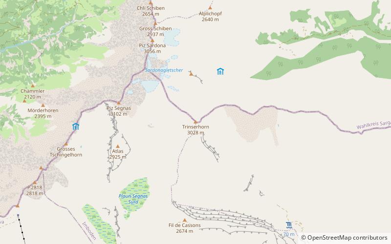
Piz Dolf or Trinserhorn is a mountain of the Glarus Alps, located on the border between the cantons of St. Gallen and Graubünden. ()
GraubündenSwitzerland
Piz Dolf plan & book
Unleash the traveler in you — discover the cheapest flight deals, find the perfect hotel or hostel nearby, and search for the best car rental prices. Travel at your own pace to discover new places and enjoy your journey.
Piz Dolf – popular in the area (distance from the attraction)
Nearby attractions include: Crestasee, Lag Prau Pulté, Vorab, Sogn Parcazi Castle and Church.
 Natural attraction, Lake, Body of water
Crestasee, Flims
143 min walk • Crestasee is a small lake shared by the municipalities of Flims and Trin in the Grisons, Switzerland. From 1892 a guest house on its northern end served as pension and still is a restaurant today in its original state. There is no tributary to the lake.
 Nature, Natural attraction, Lake
Lag Prau Pulté, Flims
136 min walk • Lag Prau Pulté is a lake at Flims in the canton of Grisons, Switzerland.
 Nature, Natural attraction, Mountain
Vorab
142 min walk • The Vorab is a mountain of the Glarus Alps, located on the border between the cantons of Glarus and Graubünden. The summit is also named Bündner Vorab to distinguish it from a lower summit named Glarner Vorab.
 Forts and castles
Sogn Parcazi Castle and Church
165 min walk • Sogn Parcazi Castle and Church is a ruined castle and fortified church in the municipality of Trin of the Canton of Graubünden in Switzerland. It is a Swiss heritage site of national significance.
 Forts and castles
Belmont
130 min walk • Belmont Castle is a ruined castle near Flims, Graubünden, Switzerland. It was the home of the Barons of Belmont.
 Nature, Natural attraction, Mountain
Crap Sogn Gion
141 min walk • Crap Sogn Gion is a mountain and cable car station located near Flims in the Swiss canton of Graubünden. Regarding the definition used in the Alps by the Swiss Alpine Club it cannot be called a mountain but only a location at the end of a ridge descending from the Vorab in the Glarus Alps.
 Nature, Natural attraction, Lake
Gigerwaldsee
136 min walk • Gigerwaldsee is a reservoir in the municipality of Pfäfers, in the Canton of St. Gallen, Switzerland. The reservoir has a volume of 35.6 million m³ and a surface area of 71 ha. The arch dam Gigerwald was completed in 1976. It has a height of 147 m.
 Nature, Natural attraction, Mountain
Ringelspitz
93 min walk • The Ringelspitz is a mountain of the Glarus Alps, located on the border between the Swiss cantons of St. Gallen and Graubünden. Reaching a height of 3,248 metres above sea level, it is the highest summit in the canton of St. Gallen. It is split between three municipalities: Pfäfers, Trin and Tamins.
 Nature, Natural attraction, Mountain
Laaxer Stöckli
84 min walk • The Laaxer Stöckli is a 2,898 metre-high mountain of the Glarus Alps, located on the border between the cantons of Glarus and Graubünden in Eastern Switzerland. It lies approximately halfway between the Vorab and Piz Segnas.
 Nature, Natural attraction, Mountain
Piz Sardona
37 min walk • Piz Sardona is a mountain in the Glarus Alps, on the border between the cantons Glarus and St. Gallen. The 3,056 metre high mountain overlooks the valleys of Elm and Calfeisen.
 Nature, Natural attraction, Mountain
Piz Segnas
34 min walk • Piz Segnas is a mountain in the Glarus Alps, located on the border between the cantons of Glarus and Graubünden. Piz Sardona is on the same ridge to the north, from where the Trinserhorn or Piz Dolf lies to the southeast.


