Laaxer Stöckli
#712 among destinations in Switzerland
![Laaxer Stöckli location map](https://tzmedia.b-cdn.net/media/images/static-maps/ch/46_8831_9_20415.jpg)
Facts and practical information
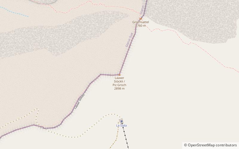
The Laaxer Stöckli is a 2,898 metre-high mountain of the Glarus Alps, located on the border between the cantons of Glarus and Graubünden in Eastern Switzerland. It lies approximately halfway between the Vorab and Piz Segnas. ()
GlarusSwitzerland
Laaxer Stöckli plan & book
Unleash the traveler in you — discover the cheapest flight deals, find the perfect hotel or hostel nearby, and search for the best car rental prices. Travel at your own pace to discover new places and enjoy your journey.
Laaxer Stöckli – popular in the area (distance from the attraction)
Nearby attractions include: Caumasee, Crestasee, Laaxersee, Lag Prau Pulté.
6.1 miSENature, Natural attraction, LakeCaumasee, Flims
157 min walk • Nestled in the heart of the Swiss Alps, the Caumasee is a stunning natural wonder in the city of Flims that beckons travelers with its serene beauty and crystal-clear waters. This picturesque lake, known for its vibrant turquoise hue, is a hidden gem that offers a...
6.6 miSENatural attraction, Lake, Body of waterCrestasee, Flims
168 min walk • Crestasee is a small lake shared by the municipalities of Flims and Trin in the Grisons, Switzerland. From 1892 a guest house on its northern end served as pension and still is a restaurant today in its original state. There is no tributary to the lake.
5.8 miSENature, Natural attraction, LakeLaaxersee, Laax
148 min walk • Laaxersee or Lag Grond is a lake in the village of Laax, Grisons, Switzerland. Its surface area is 5 ha and maximum depth 5.5 m. Fishing season is from May 1 to September 15. In winter, the lake is generally frozen.
5.1 miSENature, Natural attraction, LakeLag Prau Pulté, Flims
131 min walk • Lag Prau Pulté is a lake at Flims in the canton of Grisons, Switzerland.
2.3 miWNature, Natural attraction, MountainVorab
60 min walk • The Vorab is a mountain of the Glarus Alps, located on the border between the cantons of Glarus and Graubünden. The summit is also named Bündner Vorab to distinguish it from a lower summit named Glarner Vorab.
5.5 miSObservatories and planetariumsMirasteilas Observatory, Falera
141 min walk • The Mirasteilas Observatory is an astronomical observatory in Falera in the canton of Grisons in Switzerland. With its 90-centimeter telescope it is the largest publicly accessible observatory in Switzerland.
3.1 miSNature, Natural attraction, MountainCrap Sogn Gion
79 min walk • Crap Sogn Gion is a mountain and cable car station located near Flims in the Swiss canton of Graubünden. Regarding the definition used in the Alps by the Swiss Alpine Club it cannot be called a mountain but only a location at the end of a ridge descending from the Vorab in the Glarus Alps.
5.7 miNWNature, Natural attraction, MountainKärpf
146 min walk • The Kärpf is a mountain in the Glarus Alps, at an elevation of 2,794 m. The Kärpf is the highest point of the massif lying north of Richetli Pass.
3.3 miNENature, Natural attraction, MountainPiz Dolf
84 min walk • Piz Dolf or Trinserhorn is a mountain of the Glarus Alps, located on the border between the cantons of St. Gallen and Graubünden. Piz Sardona is to the north across a glacier, and to its west Piz Segnas. Both Piz Segnas and Piz Dolf show the line of the Glarus thrust in its upper part.
3.4 miNENature, Natural attraction, MountainPiz Sardona
87 min walk • Piz Sardona is a mountain in the Glarus Alps, on the border between the cantons Glarus and St. Gallen. The 3,056 metre high mountain overlooks the valleys of Elm and Calfeisen.
2.4 miNENature, Natural attraction, MountainPiz Segnas
61 min walk • Piz Segnas is a mountain in the Glarus Alps, located on the border between the cantons of Glarus and Graubünden. Piz Sardona is on the same ridge to the north, from where the Trinserhorn or Piz Dolf lies to the southeast.