Ortstock
#594 among destinations in Switzerland
![Ortstock location map](https://tzmedia.b-cdn.net/media/images/static-maps/ch/46_9254_8_9482.jpg)
Facts and practical information
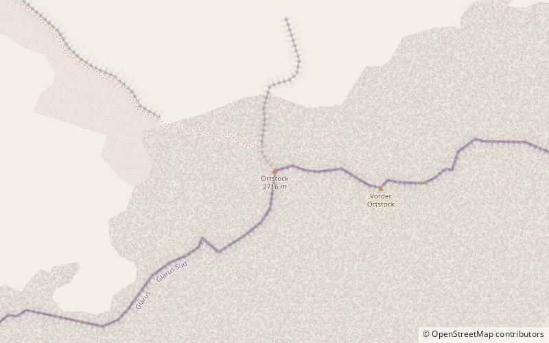
The Ortstock is a mountain in the Schwyzer Alps, located at an elevation of 2,717 m on the border between the cantons of Schwyz and Glarus. It overlooks Braunwald and Linthal on its east side, while the west side overlooks the high valley of Glattalp. ()
GlarusSwitzerland
Ortstock plan & book
Unleash the traveler in you — discover the cheapest flight deals, find the perfect hotel or hostel nearby, and search for the best car rental prices. Travel at your own pace to discover new places and enjoy your journey.
Ortstock – popular in the area (distance from the attraction)
Nearby attractions include: Oberblegisee, Glärnisch, Muttsee, Hausstock.
4.9 miNENature, Natural attraction, LakeOberblegisee
125 min walk • Oberblegisee is a lake in the Canton of Glarus, Switzerland. It is located at an elevation of 1,422 metres, above the village of Luchsingen and below the peaks of Glärnisch. Its surface area is 0.17 square kilometres.
5.6 miNENature, Natural attraction, MountainGlärnisch
144 min walk • The Glärnisch is a mountain massif of the Schwyz Alps, overlooking the valley of the Linth in the Swiss canton of Glarus. It consists of several summits, of which the highest, Bächistock, is 2,915 metres above sea level.
5.7 miSENature, Natural attraction, LakeMuttsee
145 min walk • Muttsee is a reservoir in the Canton of Glarus, Switzerland. Its surface area is 42 ha. It is used to supply water for the hydroelectric Linth–Limmern Power Stations.
6.6 miSENature, Natural attraction, MountainHausstock
168 min walk • The Hausstock is a mountain in the Glarus Alps, at an elevation of 3,158 m on the border between the cantons of Glarus and Graubünden. It overlooks the valleys of Linth and Sernf rivers in Glarus, and the valley of the Vorderrhein river in Graubünden.
4.7 miSNature, Natural attraction, MountainGemsfairenstock
120 min walk • The Gemsfairenstock is a mountain of the Glarus Alps, located on the border between the Swiss cantons of Uri and Glarus. It lies east of the Klausen Pass, on the range east of the Clariden. A trail leads to its summit via the western ridge.
5.2 miNWNature, Natural attraction, MountainSilberen
132 min walk • The Silberen is a mountain of the Schwyzer Alps, located east of the Pragel Pass in the canton of Schwyz. On its eastern side the mountain overlooks the lake of Klöntal. The summit consists of a large karstic plateau. The name, meaning silver in English, derives from the light color of the bare rock.
5.8 miSWNature, Natural attraction, Scenic drivesKlausen Pass, Altdorf
148 min walk • Klausen Pass is a high mountain pass in the Swiss Alps connecting Altdorf in the canton of Uri with Linthal in the canton of Glarus.
0.8 miNWNature, Natural attraction, MountainHöch Turm
20 min walk • The Höch Turm is a mountain in the Schwyzer Alps, located in an elevation of 2,666 m. It lies west of the resort village of Braunwald on the karstic range between the valleys of Muota and Linth.
5.1 miSENature, Natural attraction, MountainNüschenstock
131 min walk • The Nüschenstock is a mountain of the Glarus Alps, located south of Linthal in canton of Glarus. On its eastern side it overlooks the Muttsee.
5.2 miSWNature, Natural attraction, MountainGlatten Mountain
133 min walk • The Glatten is a mountain of the Schwyzer Alps, overlooking the Klausen Pass in the canton of Uri. It is the tripoint between the valleys Bisistal, Schächental and Urner Boden. The summit consists of a large karstic plateau.
2.9 miNNature, Natural attraction, MountainBös Fulen
74 min walk • The Bös Fulen is a mountain in the Schwyz Alps, located on the border between the cantons of Schwyz and Glarus. It overlooks the valleys of Muotathal and Linthal. It is the highest summit of the canton of Schwyz. Politically, it is split between the municipalities of Muotathal and Glarus. Braunwald is the nearest locality.